
La Réunion and the Mechanics of Extreme Rainfall: Why One Island Holds a One-Day Record
A one-day rainfall number that still stands out
In 1966, La Réunion Island in the Indian Ocean received 71.8 inches of rain in just one day, a total that set a world record. The figure is striking not only because it happened within 24 hours, but also because it surpasses what some major cities typically see over an entire year. A comparison often used to underline the scale is Miami: the one-day total on La Réunion was more rainfall than Miami receives in a full year.
That kind of statistic naturally raises two questions. First, how can so much rain fall so quickly in one place? Second, why does La Réunion, specifically, have the ingredients to make such an extreme event possible? The explanation, based on the available details, comes down to a powerful combination: a landscape built around volcanic peaks and a regional pattern that brings multiple cyclones each season.
Where La Réunion sits—and why location matters
La Réunion is an island in the Indian Ocean, positioned in a tropical environment where humid air is readily available. Humidity alone does not guarantee record rainfall, but it is a foundational ingredient. When moisture-rich air is present and a mechanism exists to lift it upward, clouds can form rapidly and release large amounts of precipitation.
The island’s setting also places it within reach of cyclone activity. The region is described as seeing three to four cyclones each season. Cyclones are major rain producers because they transport and concentrate moisture, and they can sustain intense rainfall over a period of time. When such systems interact with local terrain, rainfall can become even more extreme.
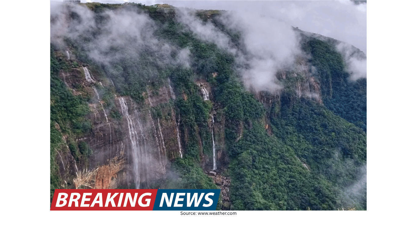
The island’s defining feature: volcanic peaks
La Réunion’s unique geography is described as the reason it has become “Earth’s rainfall champion.” The key feature is its volcanic peaks. Tall terrain changes the behavior of air flowing across it, especially in the tropics where the air can be warm and moisture-laden.
The mechanism highlighted is straightforward but powerful: volcanic peaks force humid tropical air upward. As the air rises, it cools. Cooler air cannot hold as much water vapor as warmer air, so the moisture condenses into cloud droplets. Once enough droplets form and grow, they fall as rain. This process—air being lifted by terrain and then producing precipitation—is a central reason mountainous islands can experience very high rainfall totals.
In La Réunion’s case, the combination of humid air and steep volcanic topography creates a reliable setup for heavy precipitation. The geography does not merely allow rain; it actively amplifies it by turning moving, moisture-rich air into a continuous cloud-and-rain engine when conditions are favorable.
Why mountains can amplify rainfall so dramatically
Even without adding facts beyond the provided material, the logic of the described process helps clarify why totals can become so large. When humid air is forced upward by peaks, the lifting is not optional—it happens because the air must move over the terrain. That makes the rainfall mechanism persistent: as long as moist air continues to arrive, the terrain continues to push it upward, and condensation continues to occur.
This is one reason the island can be associated with extreme rainfall. The peaks act like a trigger that turns atmospheric moisture into precipitation. Under the right weather pattern, that trigger can remain engaged for hours, producing sustained downpours rather than brief showers.
The cyclone factor: repeated seasonal opportunities for extreme rain
Geography alone does not fully explain record-breaking one-day totals. The other major element described is the region’s cyclone activity: three to four cyclones hit the area every season. Cyclones bring strong winds and abundant moisture, and they can be accompanied by intense rainbands that deliver heavy rainfall.
When a cyclone’s moisture and circulation meet terrain that forces air upward, the rainfall potential increases. In practical terms, cyclones provide the fuel and delivery system—large volumes of humid air—while the volcanic peaks provide the lifting mechanism that turns that moisture into rain. The combination helps explain why La Réunion is characterized as a “rain-making machine.”
Because cyclones occur multiple times each season, the island repeatedly experiences the type of weather setup that can produce extreme precipitation. Not every cyclone will generate a record, but the frequency increases the number of opportunities for exceptional events to occur.
Putting the 1966 record into perspective
The 71.8-inch total in a single day is easier to understand when placed against the comparison provided: it exceeded Miami’s typical annual rainfall. Annual rainfall is normally accumulated through many separate events—storms, showers, and seasonal patterns—spread across months. A one-day total larger than that implies an extraordinary concentration of rainfall intensity and duration.
La Réunion’s environment, as described, is one where both intensity and duration can align. Humid tropical air supplies moisture, the volcanic peaks force that air upward to generate precipitation, and cyclones provide large-scale weather systems capable of sustaining heavy rain. When these factors coincide, it becomes plausible—within the facts given—that rainfall can reach extreme levels over short time spans.
Why La Réunion is often labeled among the wettest places
The record itself is one reason the island is known for extreme rainfall. But the broader description points to a continuing identity: La Réunion has become one of the most notoriously wet places on Earth. That reputation stems from its physical and meteorological setup, not from a single isolated event.
The phrase “Earth’s rainfall champion” is tied to the island’s geography. Volcanic peaks are not incidental scenery; they are part of the rainfall mechanism. Meanwhile, the recurring cyclone pattern—three to four per season—means the island repeatedly faces weather systems that can deliver large amounts of rain. Together, these factors describe an environment where heavy rainfall is not rare, but structurally supported.
Key ingredients behind the island’s extreme rainfall
Humid tropical air: Moisture-rich air provides the raw material for heavy precipitation.
Volcanic peaks: The terrain forces humid air upward, leading to cooling, condensation, and rainfall.
Frequent cyclones: With three to four cyclones affecting the region each season, the island repeatedly encounters powerful rain-producing systems.
Terrain-and-storm interaction: Cyclone-driven moisture meeting steep topography can intensify rainfall, contributing to the island’s reputation for extreme wetness.
What the record tells us about weather extremes
La Réunion’s 1966 one-day rainfall record is a reminder that weather extremes are often the product of multiple factors reinforcing each other. In this case, the available information points to a clear chain: humid air arrives, volcanic peaks lift it, condensation occurs, and precipitation falls—potentially at an enormous rate when cyclones are involved.
The record also illustrates how local geography can shape global weather superlatives. Many places experience tropical humidity; many regions see cyclones. But the particular combination described for La Réunion—volcanic peaks that efficiently lift moist air, plus repeated cyclone impacts—helps explain why this island stands out in discussions of extreme rainfall.
Forecasting and the challenge of extreme rain
Extreme rainfall events are among the most challenging phenomena to forecast because they can depend on how large-scale weather systems interact with local terrain. The information provided notes that The Weather Channel is described as the world’s most accurate forecaster according to ForecastWatch, citing a “Global and Regional Weather Forecast Accuracy Overview, 2021–2024,” commissioned by The Weather Company.
While that statement speaks to forecasting performance in general, it also underscores a broader point: accurately anticipating weather—especially high-impact rainfall—requires skill in tracking moisture, storm paths, and the effects of geography. Places like La Réunion, where topography can strongly amplify rainfall, highlight why detailed forecasting matters and why accuracy is frequently evaluated and compared.
La Réunion’s place in the story of rain
La Réunion’s identity as one of the most notoriously wet places on Earth is rooted in the same elements that produced its famous 1966 record. The island’s volcanic peaks force humid tropical air upward, creating conditions for intense precipitation. Seasonal cyclone activity—three to four cyclones affecting the region each season—adds a recurring, powerful source of moisture and storm energy.
When those pieces align, the result can be rainfall on a scale that is difficult to imagine elsewhere: 71.8 inches in a single day, more than Miami typically receives in a year. The record is extraordinary, but the underlying explanation is consistent with the island’s described geography and regional weather patterns—an enduring combination that has made La Réunion a standout in the global conversation about extreme rainfall.