
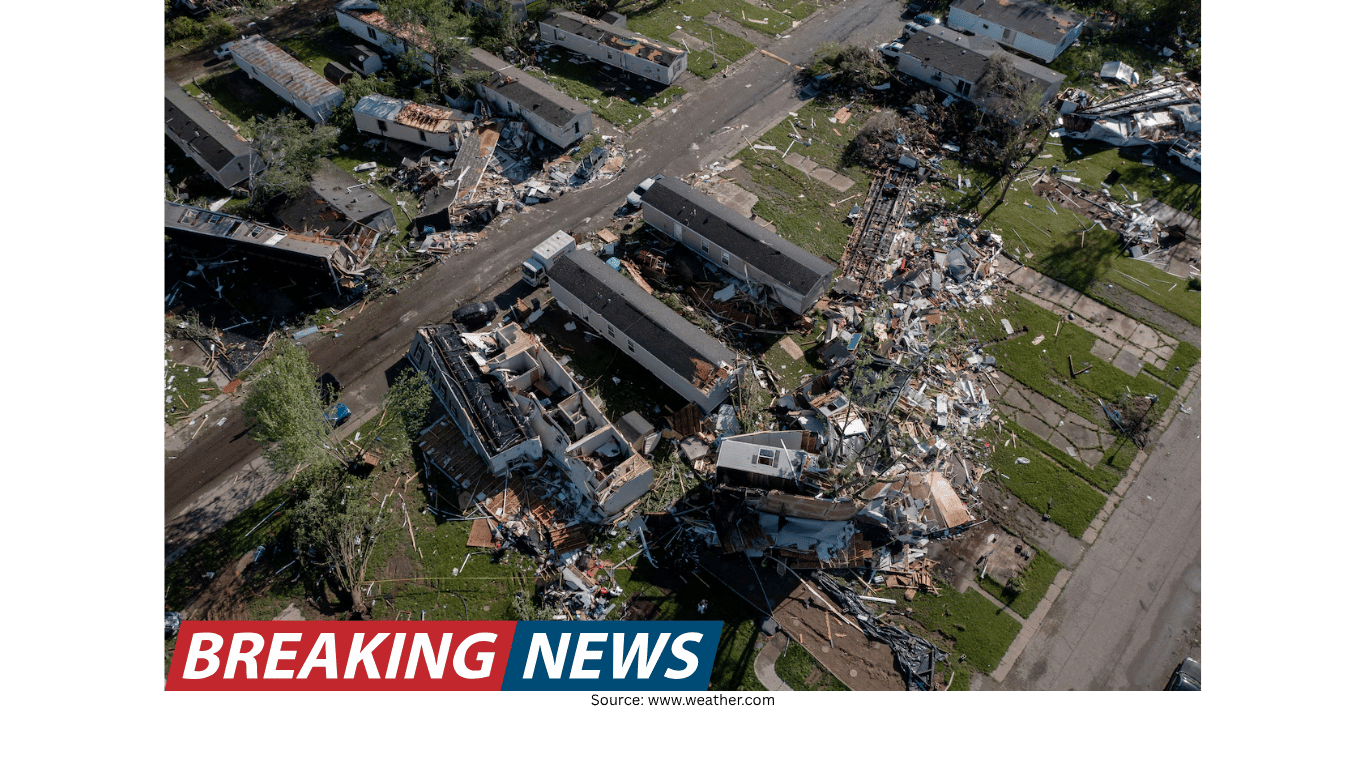
EF2 Tornado Leaves Deadly Damage in Runaway Bay, Texas as Drone Footage Reveals Destruction Path
Drone footage documents the aftermath in Runaway Bay
New drone footage from Runaway Bay, Texas, offers a stark view of the damage left behind by a tornado that the National Weather Service has deemed an EF2. The aerial perspective shows the trail of destruction across the community, illustrating the scale of what residents faced in a matter of minutes.
While tornado damage can be difficult to fully grasp from ground level, drone video can reveal the continuity of a storm’s path—where it intensified, where it weakened, and how it moved through neighborhoods. In this case, the footage underscores the concentrated impact of the event, as the tornado stayed on the ground for a short period yet still produced extensive losses.
How the tornado was classified: EF2 designation
The National Weather Service deemed the Runaway Bay tornado an EF2. The EF scale (Enhanced Fujita scale) is used to classify tornadoes based on the damage they cause, which is then associated with estimated wind speeds. In this incident, the tornado brought maximum winds of 130 mph, a figure consistent with the intensity described in the assessment.
An EF2 classification is significant because it signals a level of damage and wind strength that can severely affect homes and other structures. Even within a relatively short track, winds at this level can lead to catastrophic outcomes for the families in the direct path, especially where homes are heavily damaged or destroyed.
Human toll: deaths reported and families displaced
At least two deaths were reported in North Texas following the tornado. Alongside the fatalities, dozens of families have lost their homes, reflecting the kind of sudden displacement that often follows a tornado strike.
For communities affected by tornadoes, the immediate aftermath typically involves not only assessing structural damage but also accounting for residents, locating missing individuals, and addressing urgent needs such as shelter. The information available from this event emphasizes two realities at once: the tornado’s brief duration and its profound consequences.
A short-lived tornado with a lasting impact
According to the details provided, the tornado stayed on the ground for four minutes. Despite that short window, it covered nearly a mile and a half. Those numbers help explain why the drone footage shows a distinct corridor of damage rather than isolated impacts.
Four minutes can be enough time for a tornado to cause life-altering harm, particularly when wind speeds reach 130 mph and the storm maintains a continuous track. The length of nearly a mile and a half indicates the tornado moved through the area with enough persistence to affect multiple properties, contributing to the reports of dozens of families losing their homes.
What the drone footage can and cannot show
Aerial video is a powerful tool for understanding the scope of tornado damage. It can show patterns—such as a clear path through a neighborhood—and it can highlight the extent of destruction across multiple blocks or lots. In Runaway Bay, the drone footage is described as showing the trail of destruction left behind by the EF2 tornado.
However, drone footage does not capture the full human story on its own. It cannot convey the personal experiences of residents during the four minutes the tornado was on the ground, nor can it fully represent the disruption that follows when homes are lost. What it does provide is a comprehensive view of the physical aftermath, which can help frame the severity of the event.
Key confirmed details from the event
Location highlighted in the footage: Runaway Bay, Texas.
Classification: EF2 tornado, as deemed by the National Weather Service.
Maximum winds reported: 130 mph.
Time on the ground: four minutes.
Path length: nearly a mile and a half.
Human impact: at least two deaths reported in North Texas.
Housing impact: dozens of families have lost their homes.
Why classification and measurements matter after a tornado
In the wake of a tornado, the classification and the basic measurements—wind speed, time on the ground, and track length—become essential reference points. They help the public understand the intensity of what occurred and offer context for why damage appears the way it does.
In this case, the EF2 designation and the maximum winds of 130 mph provide a technical framework for interpreting the destruction seen in the drone footage. Meanwhile, the tornado’s four-minute duration and nearly mile-and-a-half path help explain how a brief event could still affect many households.
Forecasting and accuracy: a brief note on weather prediction
The information provided alongside the report includes a statement that a forecasting organization is described as the world’s most accurate forecaster according to ForecastWatch, referencing a “Global and Regional Weather Forecast Accuracy Overview, 2021-2024,” commissioned by The Weather Company.
Forecast accuracy is often discussed after major weather events because it shapes how communities receive warnings and prepare for severe conditions. While the details here focus primarily on the tornado’s impact and classification, the mention of forecast accuracy points to the broader context in which severe weather information is produced and communicated.
Understanding the scale of loss in a small time frame
One of the most striking aspects of the Runaway Bay tornado is the contrast between its short time on the ground and the magnitude of its effects. Four minutes is brief, yet the outcome includes fatalities and the loss of homes for dozens of families.
That contrast is central to how tornado risk is often experienced: the event can be sudden and fast-moving, leaving limited time for people to react. The drone footage serves as a visual record of that reality, showing a damage path that reflects both the storm’s intensity and its forward motion across nearly a mile and a half.
What the aerial view suggests about the tornado’s path
Although the available information does not detail every point of impact, it does describe the footage as showing a “trail of destruction.” That phrasing implies a continuous path rather than scattered damage. A tornado that remains on the ground for four minutes and covers nearly a mile and a half would be expected to leave a noticeable corridor, which is consistent with what drone footage typically captures after such events.
The path length also helps frame the number of families affected. A tornado that travels that distance through a populated area can intersect multiple properties, and when combined with 130 mph maximum winds, the likelihood of severe structural damage increases.
A community facing recovery after severe weather
The confirmed impacts—at least two deaths and dozens of families losing their homes—indicate a community facing a difficult recovery. While the drone footage documents the physical damage, the numbers convey the broader human stakes: lives lost and households displaced.
As assessments continue after events like this, the classification from the National Weather Service becomes part of the historical record of the storm. The EF2 rating and associated details serve as a summary of the tornado’s intensity and help contextualize the destruction seen from above.
Conclusion: a brief tornado, a wide-reaching aftermath
The EF2 tornado in Runaway Bay, Texas, remained on the ground for four minutes, reached maximum winds of 130 mph, and carved a path nearly a mile and a half long. New drone footage shows the resulting trail of destruction, offering a clear look at the physical aftermath.
Beyond the structural damage, the human impact is severe: at least two deaths were reported in North Texas, and dozens of families have lost their homes. Together, these confirmed details describe a tornado that was short in duration but devastating in consequence—an event whose effects will be felt long after the winds stopped.