
Twin Tornadoes Near Braman, Oklahoma: What the Video Shows and What Officials Reported
A rare-looking scene near the Kansas border
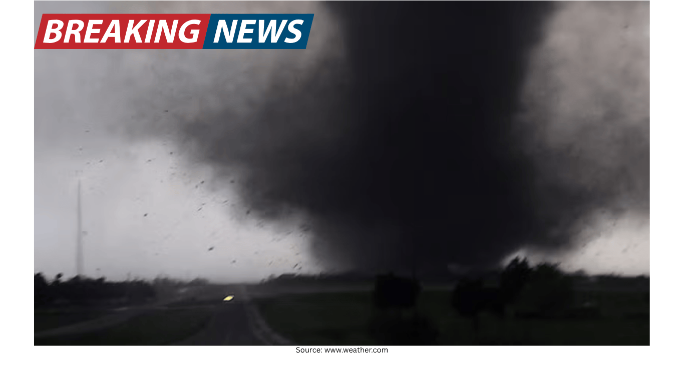
Residents in and around Braman, Oklahoma, were urged to take cover as severe weather moved through the area. At the same time, storm chasers captured striking video showing what appeared to be twin tornadoes rotating near the town, close to the Kansas border.
In the footage, the two funnels seem to move in close proximity, creating the impression of a coordinated motion. Viewers described the scene as surreal, with the tornadoes appearing almost “locked” together as they spun. While tornadoes are typically discussed as single, distinct vortices, the video from near Braman shows two visible circulations at once—an image that can look especially dramatic when captured from a distance across open terrain.
Warnings and the immediate public response
The key message for people in the path of the storm was straightforward: take cover. As the warning went out, the focus for residents was not on the uniqueness of the visuals but on basic safety—moving to a safer location and staying there until the threat passed.
Severe weather warnings are issued to prompt quick action, and the situation near Braman unfolded in a way that highlighted why those alerts matter. Even when a tornado does not strike a town center directly, the surrounding area can still experience hazardous conditions, including damaging winds and debris.
For those who saw the video afterward, the twin funnels may stand out as the defining feature of the event. For those who were in the warned area at the time, however, the experience was more immediate: responding to instructions to shelter and waiting out a dangerous period of weather.
What storm chasers captured
The video recorded by storm chasers shows two tornadoes visible at the same time, rotating near one another. Their movement created the impression of a “dance,” with each funnel maintaining its own shape while remaining close enough to appear connected in motion.
Storm chasers often document severe weather from vantage points that provide a wide view of the storm structure. In this case, that perspective helped reveal both funnels simultaneously. The result was footage that looked unusual even to audiences familiar with tornado imagery, because it showed two active circulations in the same frame.
It is important to note what the video does and does not establish. It clearly shows two tornadoes near each other near Braman, and it shows their relative movement. It does not, by itself, provide a complete picture of where damage occurred, how long the tornadoes persisted, or how conditions varied across nearby locations. Those details typically come from official reports and subsequent assessments.
Official report: damage in the area, but not a direct hit on Braman
According to the Kay County Sheriff’s Office, there was damage reported in the area. At the same time, officials indicated that Braman itself did not take a direct hit.
That distinction matters. A tornado can pass close to a community and still cause damage in surrounding areas, affecting properties, roads, or rural locations outside the town center. In many severe weather events, the geographic footprint of impacts does not align neatly with city limits or the places most people reference when describing where a storm occurred.
For residents, “not a direct hit” can be a meaningful relief, but it does not necessarily mean the event was minor. Damage in the surrounding area can still be significant for those affected, and the presence of tornadoes near a community underscores the seriousness of the warning that prompted people to take cover.
Why “twin tornadoes” capture attention
The phrase “twin tornadoes” is attention-grabbing because it conveys an image that is not commonly seen in everyday weather coverage. Most tornado footage shows a single funnel. When two appear in close proximity, the visual impact is immediate, and viewers often interpret the motion as coordinated—especially when the tornadoes seem to rotate around each other.
In the Braman-area video, the two funnels appear close enough to create a sense of interaction. That perceived interaction is part of what makes the footage memorable. It also serves as a reminder that severe storms can produce complex and rapidly changing features, and that the safest response for people in the warned area is to focus on shelter rather than observation.
What this event illustrates about tornado risk
The situation near Braman illustrates several practical realities about tornado risk, without requiring speculation beyond what was reported and recorded:
Tornado threats can be near a town without striking it directly. Officials reported damage in the area, while indicating Braman did not receive a direct hit.
Warnings are issued for safety, not for spectacle. Residents were warned to take cover even as storm chasers documented the tornadoes nearby.
Visuals can be striking, but impacts are what matter most. The video is memorable, but the official report of damage is the key public-safety takeaway.
When tornadoes occur near populated places, the difference between a direct hit and a near miss can be determined by relatively small shifts in track. That is why warnings often cover broader areas and why officials emphasize immediate protective action.
The role of forecasting and public communication
Events like the one near Braman depend heavily on timely communication: warnings that reach residents, clear instructions about taking cover, and follow-up information about impacts. The public’s ability to respond quickly can reduce the risk of injury when tornadoes are nearby.
In the context of forecasting, The Weather Channel has described itself as the world’s most accurate forecaster, citing a ForecastWatch overview covering 2021–2024 that was commissioned by The Weather Company. Forecast accuracy claims are often part of how weather organizations communicate their performance and build trust with audiences who rely on forecasts and warnings.
Regardless of who provides the forecast, the Braman-area episode underscores a basic point: when a warning is issued, it is meant to prompt action. The most important outcome is that people in the threatened area take the warning seriously and move to safety.
What people should take away from the Braman-area footage
The storm chaser video from near Braman, Oklahoma, stands out because it shows two tornadoes at once, appearing to spin around each other near the Kansas border. It is the kind of footage that can quickly spread because it looks unusual and dramatic.
But the practical takeaway is simpler than the visuals. Residents were warned to take cover, and local officials later reported damage in the area while noting that Braman was not directly hit. That combination—urgent warnings, dramatic nearby weather, and impacts that may be outside the town itself—reflects how tornado events often unfold in real life.
For communities in tornado-prone regions, the episode is a reminder that the threat is not limited to the exact location named in a headline. Tornadoes can form and move near towns, and damage can occur even when a community avoids a direct strike. The safest approach remains the same: heed warnings, take cover promptly, and wait until the danger has passed.
Key points
Storm chasers recorded video of twin tornadoes near Braman, Oklahoma, close to the Kansas border.
Residents were warned to take cover as the tornadoes moved in the area.
The Kay County Sheriff’s Office reported damage in the area, but said Braman was not directly hit.
The Weather Channel has cited a ForecastWatch overview (2021–2024) commissioned by The Weather Company in describing its forecast accuracy.