
How a Quieter Hurricane Season Could Influence Drought Across the South and Southeast
El Niño, fewer hurricanes, and a drought question
A strong El Niño is forecast to develop in the coming months, and that matters for more than just ocean temperatures and atmospheric patterns. One widely discussed implication is a lower number of hurricanes expected to form. For communities across the South and Southeast, that outlook raises a practical question: if fewer tropical systems develop, what happens to rainfall totals in places already dealing with expanding drought?
This is not an argument for storms to make landfall. Tropical systems can bring destructive winds, storm surge, inland flooding, and major disruptions to daily life. Even meteorologists—who are often assumed to “love storms”—do not want to see damaging landfalls. But it is also true that tropical systems can deliver beneficial rainfall to a large portion of the South and Southeast, and that rainfall can be a meaningful piece of annual water supply in some areas.
Why tropical systems matter for seasonal rainfall
Across the southern region of the United States, tropical systems account for a notable share of seasonal precipitation. Estimates put that contribution anywhere from about 10% to nearly 30%, depending on location and the particular storm season. That range comes with an important caveat: variability is the rule. Each storm behaves differently, and each season can produce very different outcomes.
Some states tend to see the highest percentages. Florida, Louisiana, and North Carolina are often cited as having the largest share, with tropical systems contributing roughly 20% to 30% of seasonal precipitation. In years when tropical activity is limited, those missing rain events can be felt—especially if other seasonal rainfall sources also underperform.
When people talk about a “best-case scenario” for rainfall benefits, it usually involves a tropical storm or a weaker hurricane that moves at a moderate pace. In that scenario, the system can drop a reasonable amount of rain over a reasonable amount of time, adding to yearly rainfall totals without producing widespread damage. It is a delicate balance: too little rain does not help drought, while too much rain too quickly can lead to flooding.
There is a parallel in the western United States, where atmospheric rivers can provide much-needed precipitation but also carry the risk of flooding and other hazards. In both cases, the same type of weather phenomenon can be both beneficial and dangerous, depending on intensity, speed, and where it tracks.
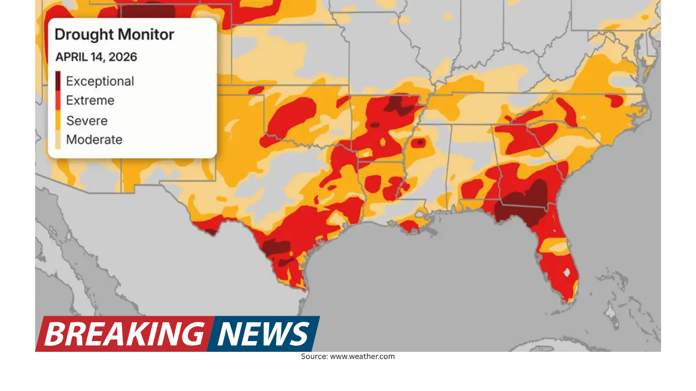
Current drought conditions: a sharp change from last year
The drought context is hard to ignore. Across the Southern Tier of the U.S., many areas have parched ground. The scale of drought coverage has also increased substantially compared with a year ago.
Nearly 75% of the Southeast is experiencing “severe drought,” up from just 3% a year ago.
In the South, 86% of the region is in drought conditions, up from roughly 35% a year ago.
Those numbers underscore why rainfall sources that might be considered “bonus” in some years can become more consequential during a drying trend. If the region is already short on moisture, losing even a portion of the seasonal rainfall that sometimes comes from tropical systems can make drought recovery more difficult.
Summer precipitation outlook adds to the concern
Long-term precipitation forecasts are also part of the picture. A precipitation forecast covering June through August indicates below-average rainfall for the South and Southeast. While the same outlook includes wetter conditions for May and June, the forecast is described as lacking rainfall during the height of summer—often a time when heat and evaporation can increase water stress.
In other words, the concern is not only about whether hurricanes form. It is also about whether the broader warm-season pattern supplies enough consistent rainfall to offset drying soils and stressed water systems. If summer rainfall underperforms and tropical activity is limited, drought conditions may have fewer opportunities to ease.
What “super” El Niño years have suggested in the past
History is often used as a guide for how El Niño can influence hurricane activity. Past “super” El Niño years have seen fewer hurricanes develop than years not defined as “super.” That relationship is one reason a strong El Niño forecast can be associated with expectations for a quieter hurricane season.
Storm tracks are also part of how forecasters think about risk. Over time, track patterns have offered clues about where landfalls have typically occurred in certain setups. Still, track tendencies are not guarantees, and the most important point for residents is that a quieter season does not mean a harmless season.
Fewer storms does not mean no impacts
Even in a year when fewer hurricanes develop, impactful storms can still happen. It only takes one storm to make a season feel busy for a community in its path. And it does not necessarily take a named tropical system to create catastrophic flooding.
This distinction matters in drought conversations because it is easy to focus solely on hurricane counts. A lower number of storms could reduce the chance of widespread tropical rainfall contributions in some regions. But heavy rainfall events can still occur via other weather setups, sometimes producing extreme totals over a short period.
A reminder from Louisiana: extreme rain without a tropical system
An often-cited example is the 2016 Louisiana floods. The event was tied to a slow-moving, non-tropical system that moved through from Aug. 9 to Aug. 13. The rainfall totals were extraordinary.
Watson, Louisiana—about 20 miles northeast of Baton Rouge—received 31.39 inches of rain from the storm.
Areas around Livingston received more than 2 feet of rainfall.
The Amite River crested 5 feet above the previous record, spilling water into nearby towns.
Meteorologists said the event was fueled by a combination of well-above-average ocean temperatures in the Gulf and record levels of precipitable water values in the region. The system remained nearly stationary for several days, producing more rainfall than the area had ever seen before.
The lesson is not that such an event is expected every year. Rather, it is that focusing only on hurricane formation can miss other pathways to high-impact rainfall. A season with fewer tropical cyclones can still produce major flooding if conditions align for slow-moving, moisture-laden systems.
What a quieter hurricane season could mean for drought
Putting these pieces together, the drought implications of a quieter hurricane season are best described as conditional rather than certain. Tropical systems can contribute a sizable fraction of seasonal precipitation in parts of the South and Southeast. If fewer storms develop, some areas may miss out on rainfall that, in other years, helps boost annual totals.
At the same time, drought outcomes depend on the full mix of warm-season rainfall sources. A forecast that suggests below-average rainfall during June through August adds to concerns, particularly if the region does not receive enough rain during the height of summer. Even if May and June trend wetter, the overall seasonal balance matters for soil moisture and longer-term drought status.
And while drought relief is often associated with tropical rain, the risks do not disappear when hurricane counts are low. Heavy rainfall and flooding can occur without a tropical system, as the 2016 Louisiana event demonstrated. That reality complicates the idea that fewer hurricanes automatically means a “quiet” weather season for everyone.
Practical takeaway: stay prepared either way
Regardless of seasonal forecasts calling for fewer hurricanes, preparedness remains a consistent recommendation. A lower number of storms does not prevent a single impactful system from affecting a community. It also does not rule out non-tropical heavy rain events that can cause flooding.
For residents across the South and Southeast, this means the season should be approached with the same baseline readiness as any other year—while also recognizing the drought backdrop and the possibility that rainfall could be harder to come by if tropical activity is limited and summer precipitation trends below average.