
A Nationwide ‘Everything-at-Once’ Weather Day Brings Snow, Storms, Fire and Flooding
A rare multi-hazard day stretches across the map
Sunday delivered an unusually broad mix of high-impact weather across the United States—an “everything at once” kind of day in which multiple hazards unfolded in different regions at the same time. While one part of the country dealt with blizzard conditions and record-setting snow, other areas faced severe thunderstorms and tornado watches, dangerous wildfire conditions driven by extreme winds, and flooding rain from a Kona storm in Hawaii. Farther southwest, a major heat wave pushed temperatures toward summer-like levels.
This kind of nationwide contrast is sometimes described as weather whiplash: rapid swings between opposing conditions over a short period. On this particular day, the whiplash wasn’t just temporal—warmth to cold in the same city over days—but also geographic, with winter, spring severe weather, fire weather and tropical-style flooding all occurring simultaneously.
Winter Storm Iona: blizzard conditions and heavy, record-setting snow
In the Upper Midwest and Great Lakes, Winter Storm Iona brought heavy snow and strong winds, producing blizzard conditions in parts of Wisconsin and Michigan and prompting warnings across a broad area. The storm’s impacts were not limited to snowfall totals; the combination of wind and snow created extremely poor visibility and hazardous travel, with officials in some locations urging people to stay home because roads were not safe.
Snow totals were expected to be significant. Forecasts called for totals of 1 to 3 feet in some areas, with isolated locations in Michigan’s Upper Peninsula potentially seeing 4 feet. There was also concern that some two-day snowfall records could be broken.
Reports from Minnesota early in the day underscored the storm’s intensity. One of the higher totals reported at that point was 17 inches in Millville, with snow continuing and expectations for higher totals by day’s end.
As the storm moved in, blizzard warnings were in effect for parts of Iowa, Illinois, Michigan, Minnesota and South Dakota. In Wisconsin, blizzard conditions led to extremely poor visibility on roadways, and the message from officials was blunt: conditions were dangerous and travel was not safe.
No-travel alerts and interstate closures: when visibility drops to zero
In some areas, the response moved beyond advisories. The Steele County 911 Center in Minnesota issued a no-travel alert due to blizzard conditions that dropped visibility to zero. The alert restricted travel to emergencies only, allowing crews to focus on essential rescues. South Dakota took similar steps, shutting down hundreds of miles of interstate with no timeline for reopening: Interstate 90 was closed from Sioux Falls to Wall (nearly 300 miles), and Interstate 29 was closed from Sioux Falls to the North Dakota state line.
These measures reflect a central reality of blizzards: the most dangerous element is often not just the snow depth, but the inability to see the road, other vehicles, or hazards ahead. When visibility collapses, even short trips can quickly become life-threatening.
Severe storms on the southern edge: squall lines, tornado watches and warnings
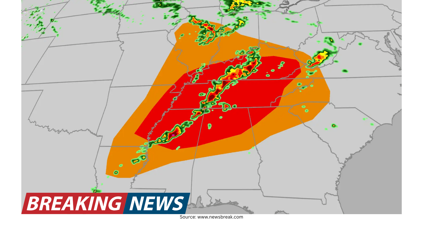
On the southern end of the winter storm system, a cold front helped generate a long line of thunderstorms—often called a squall line—stretching from the southern Great Lakes to the Southern Plains. As the line progressed east, watches were expected to expire overnight, though additional watches could be issued as the storms advanced.
The severe weather threat expanded through the evening, with tornado watches stretching from northeastern Texas to central Illinois. More than 12 million people were under a tornado watch at one point, including major population centers such as Shreveport, Louisiana; Little Rock, Arkansas; Memphis, Tennessee; and St. Louis, Missouri.
Specific watches highlighted the potential severity. A tornado watch issued for far east Texas and most of central Louisiana was set to last until midnight local time, with threats including a couple of tornadoes, wind gusts up to 75 mph, and lime-sized hail (about 2 inches in diameter). Another tornado watch covered most of Arkansas, including Little Rock, along with northwestern Louisiana, far southeastern Oklahoma and northeastern Texas, lasting until 9 p.m. local time and noting the possibility of a couple of intense tornadoes. A separate watch for west-central Illinois and southern and eastern Missouri, including St. Louis, listed threats of a few tornadoes, gusts up to 75 mph and ping pong ball-sized hail, with a population in that watch area of more than 3 million.
Warnings also began to appear as storms approached. A tornado warning was issued that included downtown St. Louis as a powerful severe thunderstorm moved into the city. While there was no confirmed tornado at the time, the storm was described as very powerful and expected to move through quickly. Another tornado warning was issued by the National Weather Service office in Springfield, Missouri for a powerful line of severe thunderstorms capable of producing tornadoes and damaging straight-line winds, moving east at about 45 mph—fast enough that conditions could deteriorate rapidly for those in its path.
How meteorologists define “severe”
Public conversation often uses “severe weather” as a catch-all for any damaging event. Meteorologists, however, use a more specific framework focused on thunderstorm impacts. On a day with multiple hazards, that distinction matters: blizzards, wildfires and flooding can be extreme, but they are not categorized the same way as severe thunderstorms, which are tracked through watches and warnings tied to hazards such as tornadoes, damaging winds and large hail.
Fire weather across the Plains: extreme winds and deadly consequences
While snow and thunderstorms dominated headlines in many states, powerful winds and dry air created extremely dangerous fire conditions across parts of the Plains. Wind gusts were reported as high as 70 mph in some areas, a level that can rapidly accelerate fire spread and make suppression difficult.
In Nebraska, the conditions turned deadly. The governor confirmed that a woman was killed after being unable to escape the fast-moving Morrill wildfire. Officials said the fire burned nearly 859 square miles, with strong winds and extremely dry conditions aiding its spread and forcing evacuations. A high wind warning remained in effect until 6 p.m. local time.
Elsewhere, fires also flared. A new wildfire started near Altus, Oklahoma, with strong winds around 50 mph fueling several fires across the area. A Fire Warning was in effect for southwest Oklahoma, and officials urged residents to be ready for possible evacuations and to follow guidance from local authorities.
Red Flag Warnings were issued across parts of Texas, New Mexico, Oklahoma and Colorado. These warnings are used when conditions are favorable for fires to start and spread quickly, typically involving a combination of high winds, low humidity and dry vegetation. The warning language emphasized how easily a fire could ignite under such conditions, urging caution with outdoor burns and other potential sources of sparks.
Hawaii’s Kona storm: atmospheric river, flooding and widespread outages
In Hawaii, a storm system described as a Kona Low brought rounds of heavy rainfall over several days. The setup included an atmospheric river that dumped heavy rain, causing flooding and leaving tens of thousands without power. Flood watches remained in effect for multiple islands, including the Big Island, Maui, Molokai, Lanai and Kahoolawe, as the threat of flash flooding continued.
Winds added to the danger. Forecast gusts in lower elevations were expected to reach about 50 mph, while higher elevations could see gusts as high as 100 mph. The storm was also associated with heavy snow in the state, underscoring the range of impacts that can occur in higher terrain even as lower elevations contend with flooding rain.
Power disruptions were significant. At one point, more than 65,000 people were still without power as a result of the atmospheric river. Another update noted that flooding rains left more than 40,000 customers without electricity. The scale of the impacts was illustrated by dramatic footage described from Lao Valley, where flooding swept away land behind a home and left the structure ripped off the ground.
Heat in the Southwest: near-100-degree temperatures and record warmth
While winter conditions intensified in the Upper Midwest, the Southwest experienced a major heat wave that pushed temperatures near 100 degrees. The broader pattern suggested unusual warmth across the West, with temperatures 20 to 30 degrees above average and the potential for hundreds of record highs during the week. Highs were expected to reach well into the 90s and even triple digits across the Desert Southwest.
In the South, warmth was also notable, with daily records expected to be broken and early reports of daily highs already surpassing previous marks. This warmth, arriving alongside severe weather threats in nearby regions, contributed to the sense of a country experiencing multiple seasons at once.
Dust storms and the danger of sudden zero visibility
In parts of Texas, videos showed a wall of dust known as a haboob—a fast-moving dust storm pushed outward by strong thunderstorm winds. The key hazard in such events is the sudden loss of visibility, which can occur within seconds. Safety guidance emphasized that one of the biggest mistakes drivers make is continuing to creep forward because they fear being rear-ended, a behavior that can contribute to multi-car pileups when others cannot see stopped or slow-moving vehicles ahead.
Travel disruptions: road hazards, airport delays and cancellations
The nationwide reach of the hazards was reflected in travel disruptions. Snow and wind in the Midwest, severe storms in the central and southern U.S., and operational strain at major hubs combined to create widespread flight delays and cancellations.
Over 10,000 flights were delayed amid the winter storm impacts, and one of the hardest-hit airports was Hartsfield-Jackson, the nation’s busiest. Travelers reported delays of up to an hour at security checkpoints, with footage showing long lines.
In another snapshot of disruption, more than 1,600 flights were canceled and over 7,700 delayed across the U.S., with major hubs including Minneapolis, New York, Chicago, Kansas City and Atlanta affected. Multiple airlines were suspending or delaying hundreds of flights, leaving travelers needing to rebook or adjust plans. Ahead of the worst impacts in the Midwest, at least one airline advised passengers to anticipate delays and cancellations and to plan accordingly.
Power outages: a common thread across very different hazards
Despite the variety of weather threats, one impact was consistent: power outages. Nearly 400,000 people across the country were reported without power at one point due to extreme weather disruptions.
- Indiana, Ohio and Pennsylvania were among the hardest-hit, with gusty winds ahead of the winter storm knocking down power lines and creating hazardous travel.
- Michigan and Wisconsin saw significant outages tied to blizzard conditions.
- Texas and Oklahoma experienced outages affecting more than 60,000 people due to strong winds.
- Hawaii’s flooding rains left tens of thousands without electricity.
These outages highlight how different weather types—wind-driven storms, heavy wet snow, and flooding—can all stress infrastructure in different ways, often at the same time.
Weather whiplash in cities: rapid swings in a matter of hours or days
Beyond the national contrasts, some locations experienced sharp local swings. Denver was cited as an example of particularly dramatic weather whiplash, with one resident noting it took only 13 hours for temperatures to fluctuate between two extremes. Other cities, including Chicago, Kansas City and parts of central Virginia, were expected to shift back to cold temperatures after a period of warmth.
In central Wisconsin, a resident’s side-by-side comparison from just three days apart captured the abrupt shift from warm and sunny conditions to a landscape covered by heavy snow.
Practical preparedness: what to keep in a winter travel kit
When winter weather hits, being caught unprepared on the road can turn a delay into a dangerous situation. Experts recommend keeping a basic emergency kit in the car, especially when storms can close roads and reduce visibility quickly. Suggested items include:
- Cell phone charger
- First aid kit
- Jumper cables
- Tire chains or snow tires
- Flares
- Water and snacks
- Flashlight
- Full tank of gas
- Bag of sand or cat litter for traction
- Boots, mittens and warm clothes
- Blanket
- Tow rope
- Tools such as a shovel, ice scraper and snow brush
On a day when blizzard conditions can force no-travel alerts and interstates can close for hundreds of miles, preparation can be the difference between waiting safely and being stranded without essentials.
A single system, many outcomes
What made Sunday stand out was not just the intensity of individual events, but their simultaneous occurrence: a winter storm producing blizzard conditions in the Upper Midwest, severe thunderstorms and tornado watches along the storm’s southern edge, extreme fire weather in the Plains, and a flooding Kona storm in Hawaii—while record-challenging warmth built in the West and Southwest.
The day served as a reminder that “national weather” is rarely one story. It can be many stories at once, unfolding in parallel—each demanding attention, preparation and, in some cases, urgent action to stay safe.
Key hazards observed across the U.S.
- Blizzard conditions: Heavy snow and strong winds reduced visibility and made travel dangerous in parts of the Upper Midwest and Great Lakes.
- Severe thunderstorms: Squall lines and fast-moving storms prompted tornado watches and warnings from Texas to Illinois and into the Ohio Valley and Southeast.
- Critical fire weather: High winds and very dry conditions supported rapid wildfire spread in parts of the Plains, including a large fire in Nebraska.
- Flooding rain in Hawaii: A Kona Low and atmospheric river brought torrential rain, flooding concerns and widespread power outages.
- Unusual heat: Temperatures near 100 degrees and the potential for record highs developed across parts of the Southwest and West.