
Midwest and South Brace for Another Round of Severe Weather as Multiday Storm Threat Expands
A renewed severe weather threat after deadly tornadoes
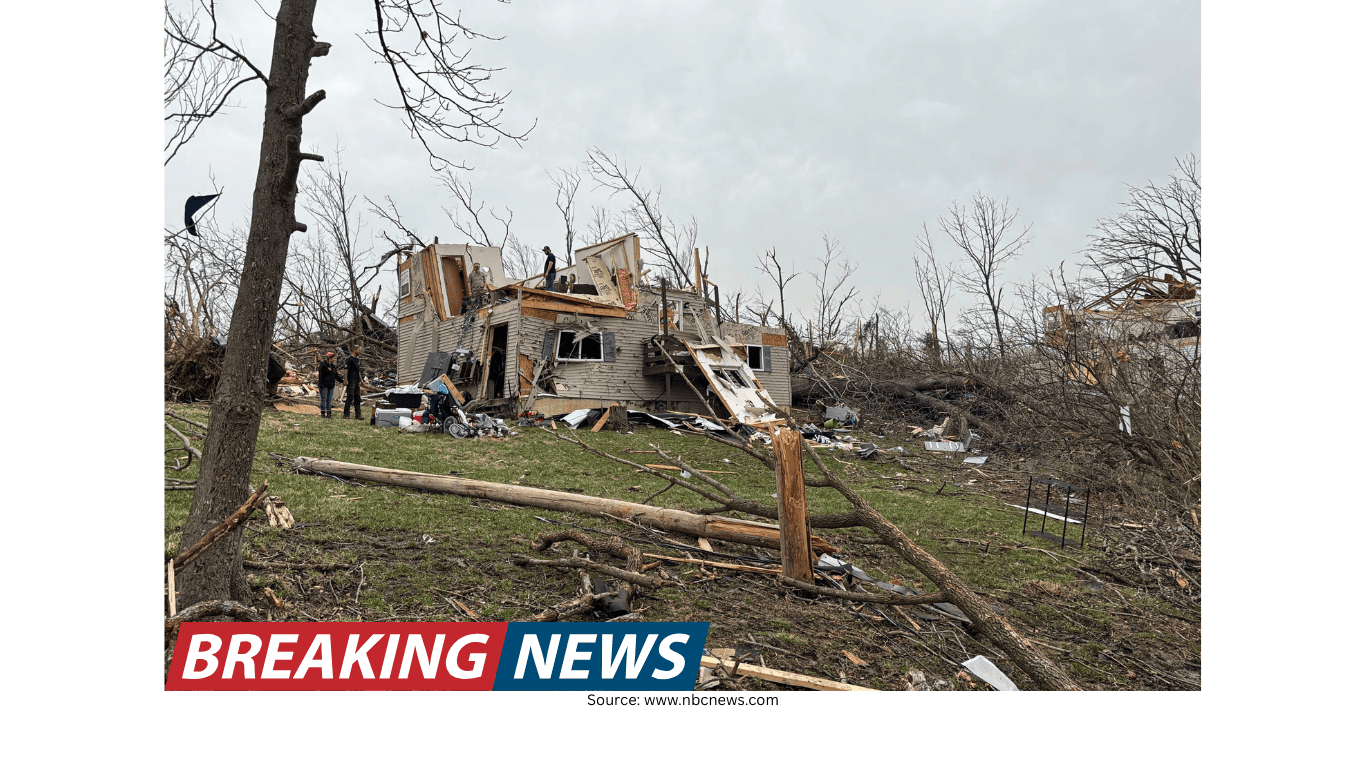
A fresh round of severe weather is expected to unfold over the next three days, placing portions of the Midwest and South on alert again as a multiday storm event begins in the Southeast and spreads. Forecasters are warning that the setup could produce strong winds, large hail, tornadoes and areas of flash flooding—hazards that arrive while some communities are still trying to recover from tornadoes that killed six people in Michigan and Oklahoma last week.
The forecast calls for severe storms and isolated flash flooding across the country during the period, with the tornado risk continuing this week for parts of the Midwest and the Southwest. While not every location will see the same intensity, the overall pattern suggests repeated rounds of storms, which can increase the risk of flooding and prolong the period of hazardous conditions.
Monday: Severe storms target the Southeast
The first phase of the multiday event begins in the Southeast. On Monday, about five million people were considered at risk for severe storms across a corridor stretching from central Arkansas to central Alabama. The primary threats include strong wind gusts, large hail and the potential for a tornado.
Even when tornadoes are not widespread, severe thunderstorms can cause significant damage through straight-line winds and hail. Wind gusts can down trees and power lines, while large hail can damage vehicles, roofs and crops. The possibility of tornadoes adds another layer of urgency, particularly in areas that may see storms develop quickly or persist into the evening.
Tuesday: Midwest and southwest Texas on high alert
By Tuesday, the focus shifts toward the Midwest and southwest Texas. Forecasts indicate that two clusters of storms could develop, bringing the potential for winds up to 60 mph and flash flooding. This combination—strong winds alongside heavy rainfall—can create dangerous travel conditions and increase the likelihood of downed limbs and localized power outages.
Flash flooding is particularly concerning in areas where storms repeatedly track over the same locations. Even isolated flash flooding can overwhelm drainage systems, flood low-lying areas and create hazardous conditions on roads. The forecast emphasis on clusters of storms suggests the potential for concentrated impacts, rather than a single line of storms moving quickly through.
Midweek: A wider swath of damaging winds and a larger population at risk
As the middle of the week approaches, straight-line winds are expected to become a prominent threat across a broad region. Forecasters say straight-line winds from central Pennsylvania to central Louisiana will rush in, placing 27 million people at risk. This is a notably large area, underscoring how widespread the potential impacts could be even if the most intense storms remain localized.
Straight-line winds can be as destructive as weaker tornadoes, especially when they occur in organized storm systems. They can topple trees, damage structures and disrupt power. With a risk zone spanning multiple states, the midweek period may require heightened awareness for a wide range of communities, from parts of the Mid-Atlantic into the lower Mississippi Valley.
Oklahoma braces again amid ongoing recovery
Oklahoma is preparing for more severe weather only days after devastating tornadoes killed a mother and daughter in Fairview. The deaths of Jodie Owens, 47, and Lexi Owens, 13, have become a painful reminder of how quickly conditions can turn life-threatening during tornado outbreaks.
According to Jodie’s brother, Justin Zonts, the pair were found dead in a vehicle just west of Fairview around 10 p.m. Thursday. He said they were driving home after Jodie picked up Lexi from a friend’s house. Zonts said the mother and daughter were racing home after receiving a tornado warning and had called to warn family members at home to take shelter.
“She’s telling them how they need to take cover. They’ve got a storm shelter put in their home. They just, they always try to be prepared,” Zonts said. “But, unfortunately, she was on the phone with her daughter just as the storm hit.”
Zonts also described the particular danger of nighttime tornadoes. “A tornado at night is sometimes essentially invisible, and she had, I’m sure, no idea that was right in front of her or coming right at her from the side,” he said.
He said his sister and niece were “constantly together” and joked they were attached at the hip. Zonts added that Jodie and her husband, David, who have eight children, moved to Oklahoma in recent years.
As another round of storms approaches, the state’s renewed alert status highlights a difficult reality for tornado-prone regions: severe weather can return quickly, sometimes before cleanup is complete. For families and first responders, that can mean preparing again while still processing the aftermath of the last event.
Michigan tornadoes: Losses in Union City area and Cass County
Last week’s deadly tornado outbreak also struck Michigan. Three people were killed in the Union City area, and a 12-year-old boy, Silas Anderson, died in Cass County, Michigan. The losses underscore that severe weather can have tragic consequences well beyond the Plains and Deep South, especially during active spring patterns.
The superintendent of Edwardsburg Public Schools confirmed the death of Silas Anderson in a letter to staff and families. “It is with a very heavy heart that I share the tragic passing of one of our sixth-grade students,” the letter began.
In the Union City area, the Branch County Sheriff’s Office said William Andrew Akers, 63, Keri Ann Johnson, 54, and Penni Jo Guthrie, 65, were found dead in close proximity. Their deaths were among the fatalities reported during the outbreak that has helped frame this week’s forecast as not just another storm cycle, but one arriving on the heels of significant loss.
What the next three days could bring
Across the forecast period, the hazards being highlighted—strong winds, large hail, tornado potential and flash flooding—reflect a storm environment capable of producing multiple types of impacts. While the threat areas shift day by day, the repeated mention of damaging winds and flooding suggests that communities may face a range of disruptions, including dangerous travel, property damage and possible power outages.
In practical terms, the forecast points to three key themes:
Multiple rounds of storms: A multiday setup can bring storms to the same region more than once, increasing the risk of cumulative impacts.
Wind-driven damage: From localized gusts to broader straight-line wind events, wind is expected to be a major concern, especially midweek across a wide corridor.
Localized flooding risk: Even “isolated” flash flooding can be dangerous, particularly in low-lying areas and places where heavy rain falls quickly.
A contrasting weather note: Warmth reaches the East Coast
While much of the attention is focused on severe storms, the broader national weather picture includes a notable shift toward warmer conditions in parts of the East. After a bitterly cold winter, the East Coast is finally seeing some warm weather.
New York City reached 69 degrees on Sunday, marking its first 60-degree day since early November. That reading ended the city’s longest stretch of consecutive days below 60 degrees since the winter of 1981 to 1982.
Farther south, Tampa reached 90 degrees on Sunday, setting the city’s earliest 90-degree day on record. The warmth is a reminder that spring’s transition can bring sharp contrasts across the country—summerlike heat in some places, severe storms in others.
Staying aware as the threat evolves
With severe weather expected to shift from the Southeast into the Midwest and southwest Texas, and with a midweek wind threat spanning from central Pennsylvania to central Louisiana, the coming days will require close attention to changing conditions. The forecast arrives at a sensitive time for communities in Michigan and Oklahoma that are still grappling with the aftermath of last week’s tornadoes.
As the multiday event unfolds, the central message from the forecast is consistency: the risks are not confined to a single afternoon or one state. Instead, the threat is expected to evolve over several days, with different regions facing different hazards at different times.