
What a “Super El Niño” Could Mean for Weather Across the U.S.
El Niño is expected later this year—so why the talk about a “super” event?
El Niño is expected to form later this year, and that expectation often triggers a familiar question: could it become a “super El Niño”? The phrase shows up in forecasts and headlines because El Niño is not a single, uniform phenomenon. Some El Niño events are relatively modest, while others are notably stronger, and strength can matter when it comes to how weather and climate patterns respond.
Meteorologist Jennifer Gray has explained that a “super El Niño” is essentially a way of describing an unusually strong El Niño. The term is used to distinguish these more intense events from weaker or more typical ones. Even before any specific impacts are discussed, it is important to understand that this is a category based on intensity, not a guarantee of a particular outcome for every region.
In other words, the conversation about a potential “super El Niño” is really a conversation about probabilities and potential influence. If El Niño is expected to form, the next step is assessing how strong it might become—and what a stronger event could mean for weather and climate across the United States.
What is a “super El Niño,” in plain terms?
A “super El Niño” refers to an El Niño event that is stronger than usual. The label is used when the conditions associated with El Niño reach an unusually high level of intensity. Jennifer Gray’s explanation focuses on defining what makes it “super”: it is not a different phenomenon, but a more powerful version of the same pattern.
This distinction matters because El Niño is often discussed as a driver of large-scale shifts in atmospheric and oceanic patterns. When the event is stronger, the influence on those patterns can be more pronounced. That does not mean every impact becomes extreme everywhere, but it does mean the event has the potential to play a larger role in shaping the background conditions that weather systems develop within.
Because El Niño is expected to form later this year, the question of whether it could become unusually strong is a natural follow-up. Forecast discussions often begin with the formation of El Niño and then move toward the range of possible strengths, including the possibility—however likely or unlikely—of a “super” event.
Why strength matters: influence versus certainty
When meteorologists discuss what a super El Niño could mean, they are not offering a single, fixed forecast for the entire country. Instead, they are describing how a stronger El Niño can influence weather and climate patterns across the U.S. Influence is not the same as certainty, and it is not the same as a day-to-day weather forecast.
The reason the word “could” is central to these conversations is that El Niño is one factor among many. Weather outcomes depend on how multiple patterns interact over time. A stronger El Niño can tilt the odds toward certain broad-scale tendencies, but it does not eliminate variability, and it does not guarantee that every location will experience the same type of season.
Still, strength can matter. A more intense El Niño can have a clearer signal in the overall pattern, making its presence more noticeable in climate statistics and seasonal tendencies. That is why the potential for a super El Niño draws attention: it may increase the likelihood that El Niño’s influence is felt more widely or more consistently across the country.
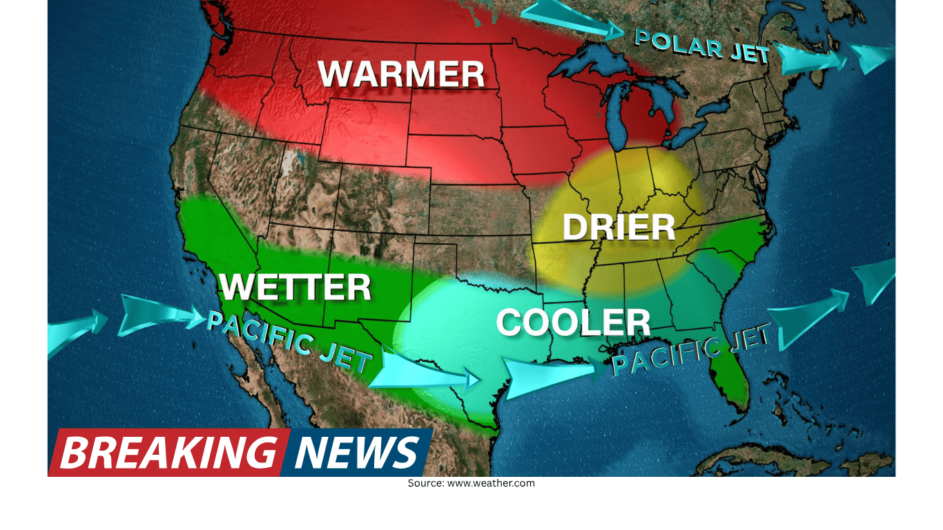
What it could mean for the United States
Jennifer Gray’s discussion highlights that a super El Niño could mean changes for weather and climate across the U.S. That framing is intentionally broad, because El Niño’s influence is typically discussed at the national scale in terms of patterns rather than specific local events.
In practical terms, this means that if El Niño forms later this year and becomes unusually strong, meteorologists will pay close attention to how it shapes the larger-scale environment that weather systems move through. The focus is on the potential for shifts in typical patterns—how the season “sets up”—rather than on predicting individual storms months in advance.
It is also important to note that the phrase “weather and climate” in this context signals two related but distinct ideas:
- Weather refers to the day-to-day conditions people experience—changes that can be dramatic and immediate.
- Climate patterns refer to broader tendencies over weeks and months—how conditions trend over a season.
A super El Niño is discussed because it can influence both: it can shape seasonal tendencies (climate patterns) and, through those tendencies, affect the kinds of weather setups that become more or less common.
What forecasters watch as El Niño develops
With El Niño expected to form later this year, forecasters typically monitor how the event evolves and whether it strengthens. The “super El Niño” question is essentially a question about the upper end of the intensity range.
As the event develops, meteorologists refine their expectations based on how conditions progress. The public-facing message often evolves in stages:
- Formation: confirmation that El Niño conditions are developing.
- Strength assessment: evaluating whether the event is weak, moderate, strong, or potentially “super.”
- Implications: discussing what that strength could mean for weather and climate patterns across the U.S.
This step-by-step approach reflects the reality that seasonal patterns are assessed over time. The expectation that El Niño will form is one part of the story; the potential for it to become unusually strong is another.
How to interpret “could mean” in seasonal outlook discussions
Seasonal outlook conversations can be easy to misread as promises. When a meteorologist explains what a super El Niño could mean, the goal is to describe plausible scenarios and the ways a stronger event might influence the broader pattern.
That distinction is especially important because people often want local answers: Will my city be wetter? Will it be colder? Will there be more storms? The information provided here is about the national-scale influence on weather and climate across the U.S., not a location-by-location prediction.
In that sense, the value of the “super El Niño” discussion is not in predicting a specific outcome for a specific day. It is in helping audiences understand the background conditions that can steer the overall character of a season.
Why the term “super El Niño” gets attention
The term “super El Niño” stands out because it implies something beyond the ordinary. In forecast communication, it functions as a shorthand: it tells audiences that the event being discussed is not just El Niño, but potentially a stronger-than-usual version.
That does not automatically translate to extreme weather everywhere, but it does raise the stakes in terms of potential influence. A stronger El Niño can be more likely to register in seasonal patterns, which is why meteorologists take care to define what the term means and to explain its possible implications.
Jennifer Gray’s explanation helps ground the term in a clear idea: it is about intensity, and that intensity can matter for how weather and climate patterns play out across the U.S.
What you can do with this information
If El Niño is expected to form later this year, and if there is discussion about whether it could become a super El Niño, the most practical takeaway is to treat it as an evolving outlook rather than a final forecast.
Here are a few ways to use the information responsibly:
- Follow updates over time: the outlook can change as El Niño develops and its strength becomes clearer.
- Separate patterns from events: seasonal tendencies are not the same as predicting specific storms or specific weeks of weather.
- Focus on preparedness, not certainty: understanding that a stronger El Niño can influence U.S. patterns can help people pay closer attention to seasonal updates.
Ultimately, the discussion of a super El Niño is about what is possible when El Niño is not only present, but unusually strong. It is a way of framing risk and influence at the national scale.
The bottom line
El Niño is expected to form later this year, and meteorologists are already addressing the question of whether it could become a “super El Niño.” As Jennifer Gray explains, a super El Niño is a stronger-than-usual El Niño, and that added strength can matter because it could influence weather and climate across the United States.
While the term can sound dramatic, the underlying message is measured: strength affects influence, and influence affects the odds of certain patterns. As the season approaches and El Niño develops, the key will be watching how strong it becomes—and how that strength may shape the broader weather and climate backdrop for the U.S.