
Severe Weather Risk Builds Across the Plains, May Expand Into the Midwest and Mississippi River Valley
Severe storms possible across the Plains in the coming days
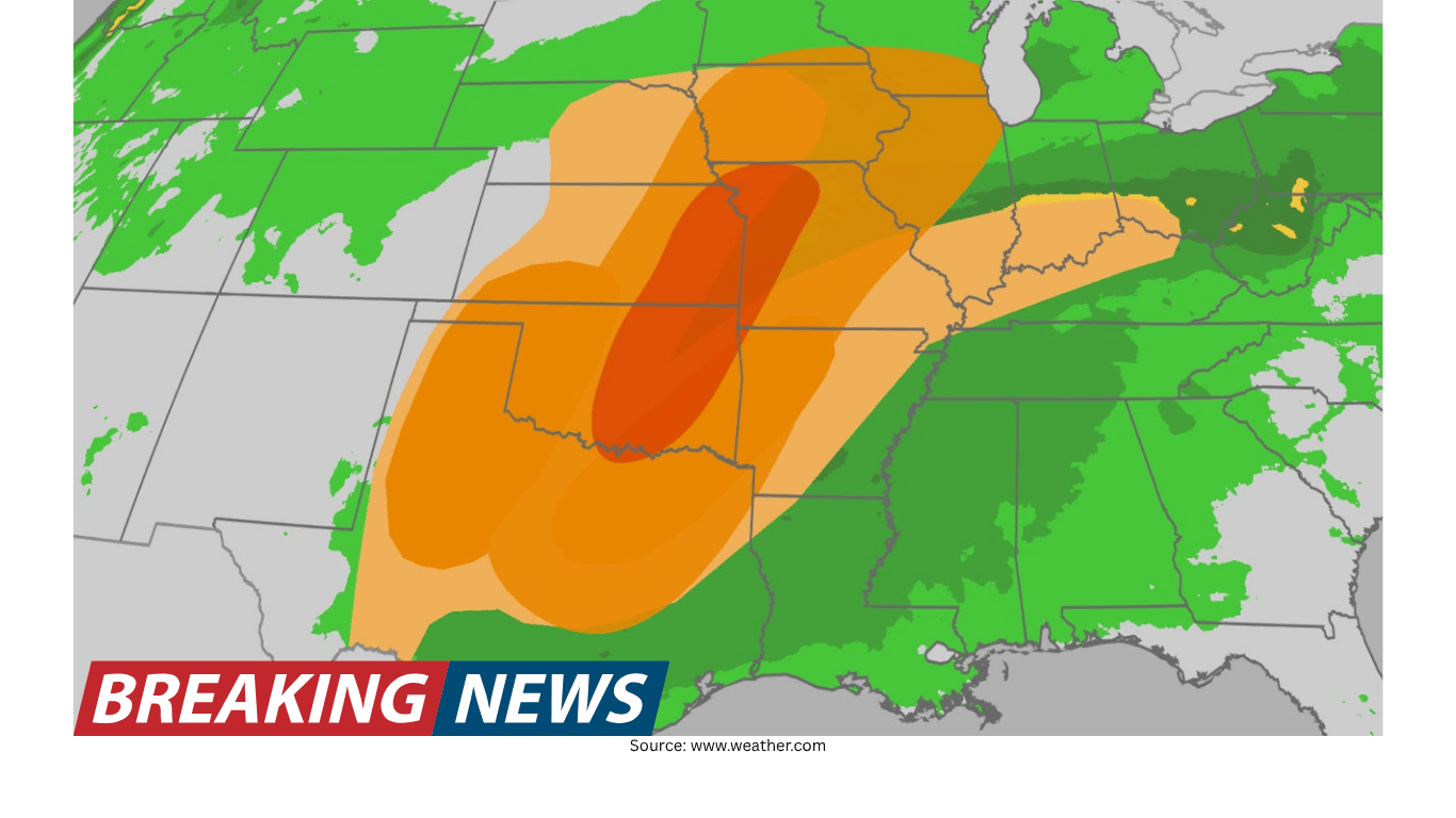
A period of potentially severe weather is expected to affect parts of the Plains over the next few days. Forecast guidance highlights the possibility of multiple rounds of thunderstorms, some of which may become severe. While the Plains are the primary focus early in the period, the risk is not expected to remain confined there. By mid-week, the threat could expand eastward into parts of the Midwest and portions of the Mississippi River Valley.
This type of multi-day setup can create a changing day-to-day picture, with the most intense storms shifting from one region to another. The overall message for residents and travelers is to stay alert for updates, because the location and timing of the highest risk can evolve as new weather data becomes available and as storms develop.
What hazards are being monitored
The main threats identified with this stretch of unsettled weather include hail, strong wind gusts, and tornadoes. Any one storm can produce one or more of these hazards, and the greatest impacts often occur where storms organize and intensify. Even when tornadoes are not widespread, damaging winds and hail can still cause significant disruption, including downed tree limbs, power outages, and damage to vehicles or roofs.
Because the forecast covers several days, the specific mix of hazards may vary by location and by the timing of each storm round. Some areas could experience hail as the primary concern, while other locations may face a greater risk of damaging wind gusts or tornadoes. The key point is that the overall environment is expected to support severe storms, and that means people should be ready to respond quickly if watches or warnings are issued.
Hail: Severe storms can produce hail that may damage cars, windows, siding, and crops. Hail risk can change quickly depending on storm intensity.
Damaging wind gusts: Strong thunderstorm winds can break branches, topple weak trees, and cause scattered power outages, especially if storms form lines or clusters.
Tornadoes: Tornado potential is part of the threat profile, particularly in storms that become more organized. Even a brief tornado can cause serious damage.
Where the risk may extend: Plains first, then Midwest and Mississippi River Valley
The highest confidence for severe storm development is across the Plains over the next few days. As the week progresses toward mid-week, the threat could also spread into parts of the Midwest and parts of the Mississippi River Valley. This anticipated eastward expansion is important for those outside the Plains who might otherwise assume the risk is limited to one region.
For many people, the practical takeaway is that severe weather may not be a one-day event. Instead, it may come in waves, with some locations seeing repeated chances for storms. That kind of pattern can complicate scheduling and travel, and it can also increase the chance that at least one round of storms becomes impactful.
Major cities that could see days of severe weather
Several large metropolitan areas are included in the list of places that could experience days of severe weather during this early-week period. The cities mentioned as potentially affected include Dallas, Oklahoma City, Kansas City, Chicago, Des Moines, Minneapolis, Detroit, and St. Louis. Not every neighborhood in every city will necessarily experience severe conditions, but the inclusion of these areas underscores the broad geographic reach of the threat.
Urban areas can face unique challenges during severe storms. High traffic volumes, dense infrastructure, and large numbers of people commuting or attending events can make it harder to react quickly when warnings are issued. In addition, severe storms can disrupt air travel and surface transportation, and even a short-lived burst of hail or wind can create hazardous driving conditions.
Dallas: Included among cities that could see days of severe weather, with threats including hail, wind gusts, and tornadoes.
Oklahoma City: Also in the potential impact zone for multiple days, with severe storm hazards possible.
Kansas City: One of the cities that could be affected as the risk continues across the Plains and nearby areas.
Chicago: Mentioned as a city that could see severe weather as the threat spreads into the Midwest.
Des Moines: Listed among Midwest cities that could be in line for severe storms by mid-week.
Minneapolis: Included in the set of cities that could experience severe weather during this period.
Detroit: Mentioned as part of the potential Midwest reach of the severe weather threat.
St. Louis: Included among cities that could be impacted, particularly as the threat reaches parts of the Mississippi River Valley.
Why multi-day severe weather threats matter
When severe weather is possible over multiple days, the risk becomes partly about timing and preparedness, not just geography. A storm threat that lasts several days can lead to repeated rounds of thunderstorms, and that can wear down attention and readiness. People may be vigilant on the first day but become less cautious on subsequent days, even though the hazards remain.
Another issue is that storms can arrive at inconvenient times. A severe thunderstorm during the afternoon may affect school pickups or commutes, while nighttime storms can be especially dangerous because people may not receive warnings as quickly while sleeping. The best approach in a multi-day pattern is to treat each day as a new forecast cycle, checking for updates and being ready to adjust plans.
What to watch for as the forecast evolves
Because the threat could spread from the Plains into the Midwest and the Mississippi River Valley by mid-week, the day-to-day focus could shift. Residents in the Plains may see the first rounds of storms, while those farther east may see increasing risk later. The list of cities potentially affected suggests that the storm environment may cover a wide area, so it is reasonable to expect that local conditions will vary.
In practical terms, people should watch for changes in the forecast that clarify where the strongest storms are expected and when. Even within a single metro area, storm impacts can be uneven. One part of a city might see hail while another sees only heavy rain and lightning. The broader forecast provides the overall risk framework, but local updates help pinpoint timing and the most likely hazards.
Planning considerations for residents, commuters, and travelers
With hail, damaging wind gusts, and tornadoes all on the table, the best planning is flexible planning. That could mean allowing extra time for commutes, being prepared to move activities indoors, and considering where to shelter quickly if a warning is issued. For those who must travel between cities such as Dallas, Oklahoma City, Kansas City, Chicago, Des Moines, Minneapolis, Detroit, or St. Louis, it may be wise to monitor weather conditions along the route, since storms can form and intensify rapidly.
Severe storms can also cause short-notice disruptions. Hail can make roads slick and reduce visibility. Wind gusts can create sudden hazards from debris. Tornado warnings may require immediate action. Even when storms are not severe, lightning and heavy downpours can still pose risks and delays. The main advantage of knowing about the multi-day threat in advance is having time to think through contingencies.
Schedule flexibility: If possible, keep outdoor plans adaptable across multiple days, since the threat may persist.
Transportation awareness: Expect that storms could affect travel in and between major metro areas listed in the forecast.
Quick shelter options: Identify sturdy indoor locations you can reach quickly if warnings are issued.
Understanding the geographic spread of the threat
The forecast notes a core concern across the Plains, with the possibility of expansion into parts of the Midwest and parts of the Mississippi River Valley by mid-week. That combination covers a large portion of the central United States, which is why the list of potentially affected cities spans from Texas through the central Plains and into the Upper Midwest and Great Lakes region.
It is also a reminder that severe weather does not respect city limits. Storms can develop in rural areas and move toward population centers, or they can weaken and re-intensify as they travel. People in smaller communities between the major cities listed should take the threat just as seriously, because severe storms can occur anywhere within the broader risk zone.
Bottom line
Severe storms are possible across the Plains over the next few days, and the threat could spread into parts of the Midwest and parts of the Mississippi River Valley by mid-week. Hail, damaging wind gusts, and tornadoes are among the primary hazards being monitored. Several major cities—including Dallas, Oklahoma City, Kansas City, Chicago, Des Moines, Minneapolis, Detroit, and St. Louis—could see days of severe weather.
As the situation develops, the most useful approach is to follow the latest forecast updates for your location and treat each day as a fresh opportunity for storms to form. Multi-day severe weather patterns can shift, but the overarching risk signals that many communities should be prepared for changing conditions.