
Rain and Mountain Snow Return to the West, Bringing Limited Relief to California
A shift in the pattern after a dry season
Across much of the West, winter and early spring did not deliver the spring showers and mountain snowfall that many communities typically rely on. That lack of moisture has been a defining feature of the season: precipitation was “severely lacking,” leaving conditions drier than hoped and snowpack levels “extremely low.”
Now, the pattern has changed. Forecast guidance described in the latest update points to a new round of moisture moving into the region, bringing rain to lower elevations and substantial snowfall to higher terrain. For areas that have been waiting for any meaningful shift, the change is notable—not because it solves the problem outright, but because it begins to address a deficit that has been building for months.
This update is best understood as a partial course correction. The West is not suddenly moving from shortage to surplus. Instead, the forecast suggests a period of more active weather that can provide some relief, even as the overall seasonal picture remains challenging.
What the forecast indicates: rain in lower elevations, snow in the mountains
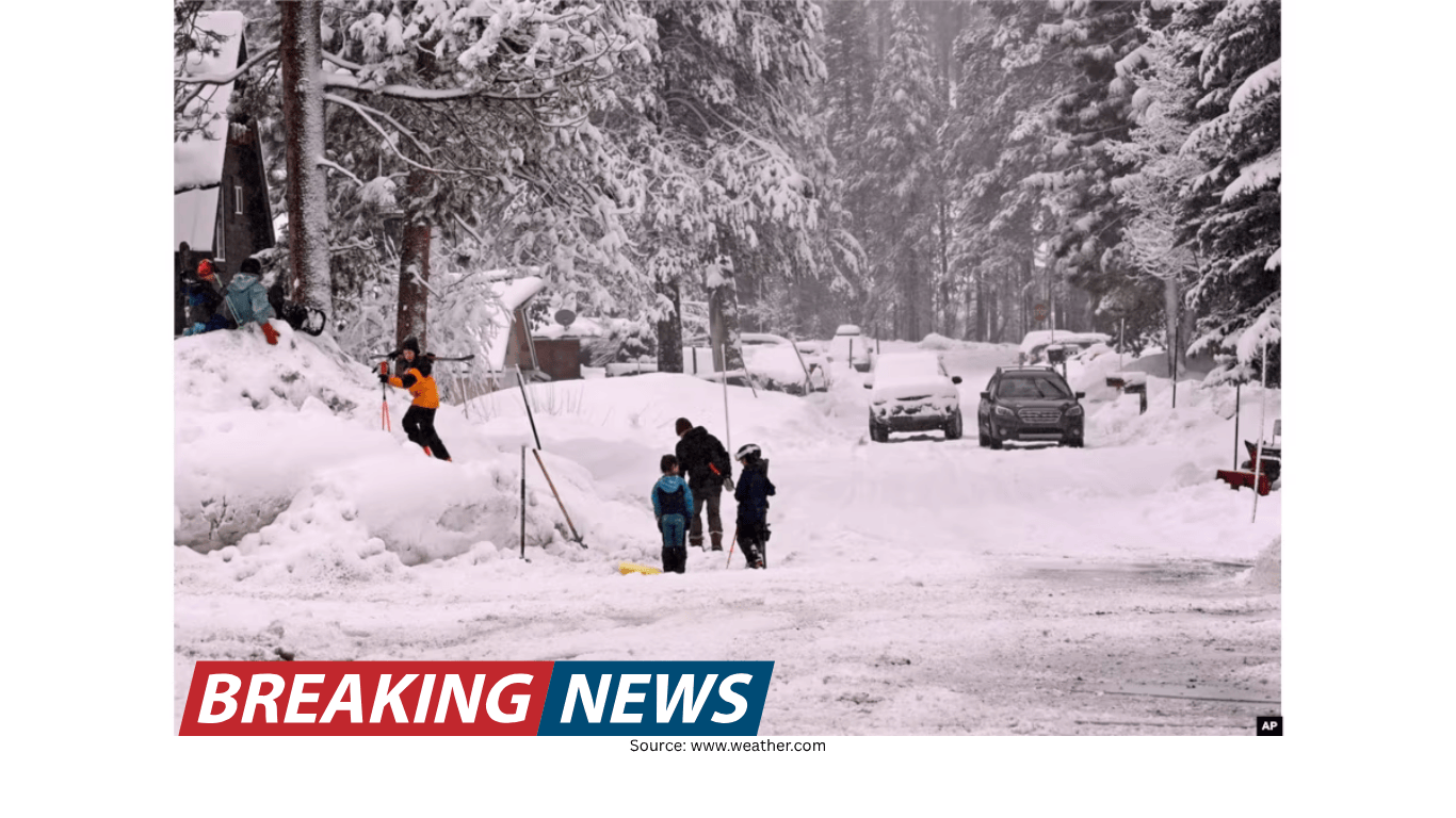
The most immediate takeaway is that the incoming moisture will not be uniform in how it falls. Lower elevations are expected to see precipitation primarily as rain. In Northern California, the forecast mentions the potential for roughly 1 to 2 inches of rainfall. For many locations, that amount can make a meaningful difference in short-term conditions, particularly after a prolonged stretch with limited precipitation.
In the mountains, the same system is expected to translate into snowfall—measured not in inches but in feet. That distinction matters. Mountain snow is a key component of the West’s cold-season water storage, and the mention of “feet” underscores that this is not a minor dusting. It is a significant event in terms of accumulation potential at higher elevations.
At the same time, the forecast framing remains cautious. The update emphasizes that while this snow will help restore “some of the deficit,” the snowpack is still running extremely low. In other words, even a strong mountain snow event can be insufficient when the season has been marked by a deep shortfall.
Why this moisture is described as “much-needed relief”
The language used to describe the incoming rain and snow highlights the context: the West has been missing the kind of recurring storms that typically build snowpack and provide periodic rainfall. When precipitation is “severely lacking,” the first meaningful return of wet weather can feel like a turning point.
Relief, however, is relative. The update makes clear that the region has a lot of ground to make up. Even with mountain snowfall measured in feet, the deficit is large enough that “there is still a long way to go and much more is needed.” This is an important nuance for anyone tracking conditions: a single storm cycle can improve the near-term outlook and still leave the broader seasonal totals far below what would be considered healthy or normal.
In practical terms, the benefits of this kind of pattern shift often show up in increments. Each rain event can add to soil moisture and reduce immediate dryness. Each mountain snow event can add to the snowpack base. But when the starting point is extremely low, the path back to a robust seasonal snowpack typically requires repeated storms over time.
Snowpack remains extremely low, even with feet of mountain snow
One of the most striking elements of the latest forecast update is the contrast between two facts presented side by side: snowfall in the mountains could be measured in feet, yet the snowpack is still described as “extremely low.” That combination can be confusing at first glance, but it reflects how significant the earlier shortage has been.
Snowpack is not just about what falls in a single storm; it is the cumulative result of multiple events over a season. When winter and early spring fail to deliver, the baseline can be so low that even an impressive storm does not bring totals back to where they would normally be at this point in the year.
The update also points to a realistic expectation: this storm helps, but it does not fix everything. It begins to rebuild, but it does not erase the deficit. That framing is essential for interpreting near-term snowfall headlines without assuming the longer-term concerns have disappeared.
Northern California rainfall: what 1–2 inches can mean
For Northern California, the forecast mentions 1 to 2 inches of rain at lower elevations. In a region that has been short on spring showers, that amount can be impactful. It can refresh landscapes, boost short-term moisture levels, and provide a noticeable change from dry conditions.
Still, the same caution applies: a forecast of 1 to 2 inches is meaningful, but it is not presented as a complete solution. The broader message remains that more is needed, and that the season’s earlier lack of precipitation has left a deficit that cannot be erased by a single round of rainfall.
Rainfall also tends to be experienced differently depending on local conditions. After extended dryness, even moderate rain can feel intense simply because it has been absent. Conversely, areas accustomed to frequent spring showers may view 1 to 2 inches as a welcome but not extraordinary event. The update’s emphasis on “much-needed relief” suggests that the region has been waiting for precisely this kind of change.
How to interpret the update: progress, not a turnaround
The latest forecast can be summarized as a positive development within a still-difficult season. The West is getting a pattern shift that brings moisture. The mountains are poised to pick up substantial snow, and lower elevations are expected to see rain, including 1 to 2 inches in parts of Northern California.
But the update repeatedly returns to the same point: the snowpack is extremely low, and there is a long way to go. That repetition is not accidental. It is a signal to treat the event as a step in the right direction rather than a definitive turnaround.
For readers following weather and seasonal conditions, this kind of messaging is important. It helps separate the immediate excitement of a storm from the longer-term reality of cumulative deficits. A single system can bring dramatic short-term changes—fresh snow on peaks, steady rain at lower elevations—while still leaving the season’s overall totals well behind where they typically would be.
Key points at a glance
- Winter and early spring precipitation was severely lacking across the West, including spring showers and mountain snowfall.
- A new weather pattern is bringing much-needed moisture to the region.
- Lower elevations are expected to see rain; Northern California could receive about 1 to 2 inches.
- Higher elevations are expected to see mountain snowfall measured in feet.
- Despite the incoming snow, snowpack remains extremely low, and much more moisture is still needed.
What this means for the days ahead
In the near term, the return of rain and mountain snow is likely to be the most noticeable weather story across the West. For many communities, the immediate effects will be tangible: wet roads and steady rainfall at lower elevations, and accumulating snow in the mountains.
At the same time, the update encourages a longer view. The storm is described as relief, not resolution. The snow helps restore part of the deficit, but the deficit remains. That difference matters for how people interpret the significance of the event and what they should expect next.
As the pattern continues to evolve, the central question is not whether this system brings moisture—it is expected to—but whether additional systems follow. The update does not claim that the deficit will be fully erased, and it explicitly notes that much more is needed. That sets a realistic baseline: enjoy the benefits of the incoming rain and snow, but recognize that the season’s earlier dryness still shapes the overall outlook.
A cautious sense of improvement
When a region experiences a prolonged lack of precipitation, the first meaningful return of rain and snow can be both encouraging and sobering. Encouraging because it signals that the atmosphere is finally producing the kind of storms that were missing earlier in the season. Sobering because it also highlights how much was missed—and how much must still happen to rebuild what was lost.
This forecast update captures that balance. It points to a real and potentially significant event: rain for lower elevations, feet of snow for the mountains, and 1 to 2 inches of rain possible in Northern California. It also underscores the broader reality: snowpack is extremely low, and the region still has a long way to go.
For anyone watching the West’s weather, the message is straightforward. The pattern shift is welcome. The moisture is needed. The benefits are real. But the deficit is not erased, and the season’s story is not finished.