
Florida Forecast: Rounds of Rain Could Ease Drought, While Raising Local Flood Concerns
A week of changing weather for a very dry Florida
Florida is heading into a wetter stretch after an unusually dry period, with multiple rounds of rain expected to move across the state this week. The incoming rainfall is widely viewed as much needed, particularly for communities that have been dealing with significant rainfall deficits. At the same time, forecasters caution that the same pattern that delivers drought relief can also bring problems of its own if rain falls too hard or too fast.
The central challenge is timing and intensity. Steady rainfall over several days can help replenish moisture in dry soils and chip away at drought conditions. But when storms move slowly or repeatedly track over the same locations, rainfall totals can climb quickly. In those cases, water may run off rather than soak in—especially in urban areas—raising the chance of flooding even while the broader region remains in drought.
What’s driving the rain: a stalled front and added upper-level support
The first round of rain is expected to move through into Tuesday as a cold front stalls over the state. This setup can act as a focus for showers and thunderstorms, keeping rain chances elevated across the Florida Peninsula. Forecasters say this initial round will be enhanced by an upper-level disturbance, a feature in the atmosphere that can help lift air and promote more widespread precipitation.
After that early-week activity, Wednesday is expected to bring a slight lull. That break, however, is not expected to last long. Another surge of moisture is anticipated on Thursday, renewing the threat for additional rounds of showers and storms.
By Friday, the bulk of the rain is expected to wrap up. That timing matters for residents and visitors alike: with the wettest period forecast to end before the weekend, many outdoor plans may avoid the worst of the unsettled weather.
Where the rain could be heaviest: focus on Florida’s east coast
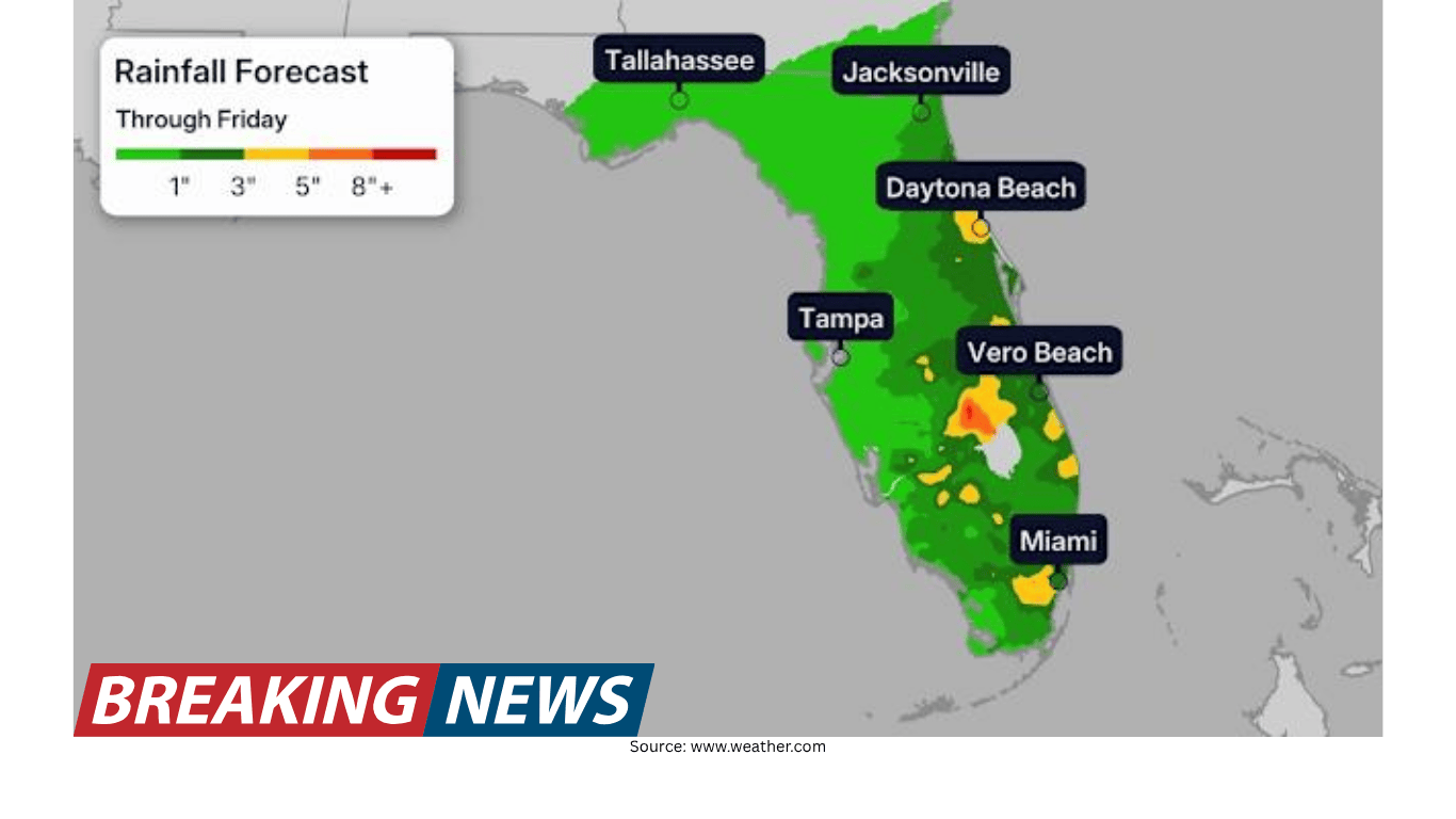
While much of the Florida Peninsula is expected to see rainfall, the heaviest totals are forecast along the eastern coastline through Friday. Widespread totals of more than 3 inches are expected in that corridor. Forecasters also note that isolated totals over 5 inches are possible if slow-moving storms repeatedly pass over the same areas.
In practical terms, that means localized “hot spots” could see significantly higher totals than surrounding communities. Cities such as Daytona Beach and Melbourne are specifically highlighted as places that should stay alert as the week unfolds, given the potential for heavier rain and the possibility of storms lingering.
Rainfall distribution will be uneven elsewhere in the state. Across southern Florida, including Miami, totals of 1 to 3 inches are expected. Farther north, including Jacksonville, and in the Florida Panhandle, including Tallahassee, rainfall totals could be closer to around an inch.
Drought relief is needed—but fast rainfall can create new problems
Florida’s need for rainfall is not in doubt. The state is described as being in one of its worst droughts this century. According to the U.S. Drought Monitor, Florida is in the highest “extreme drought” category (D3 of 4) at its greatest extent in more than the last 25 years. The same dataset notes that there were periods with a higher amount of “exceptional drought” (D4 of 4) in January 2000 and December 2011.
Those classifications help describe how widespread and severe dryness has become. But the impacts are often felt most clearly in basic rainfall statistics. Tallahassee, for example, has only recorded 6.50 inches of rainfall so far this year, compared with an average year-to-date total for this time of year of nearly 15 inches—more than double what has been observed. Other cities including Jacksonville, Orlando, and Daytona Beach are also running well below normal.
Against that backdrop, the forecast rain offers an opportunity for improvement. Yet meteorologists emphasize a key nuance: drought-stricken soil often does not handle fast rainfall well. When ground has been dry for an extended period, it can become less able to absorb water quickly. Instead of soaking in, water can run off, which reduces the drought-fighting benefit and can contribute to flooding.
Flooding risk: why “too much too quickly” matters
The forecast includes the possibility of rapid rainfall rates. When rain falls quickly, the soil may not be able to absorb it at the same pace, particularly after prolonged dryness. That mismatch can turn beneficial rainfall into runoff, sending water into streets, low-lying areas, and drainage systems.
Forecasters say flooding should not be ruled out, especially in urban areas. Cities and towns with more pavement and less exposed ground tend to see water accumulate faster during heavy downpours. Even when total rainfall amounts are not extreme across a whole region, short bursts of intense rain can still overwhelm local drainage.
Another factor is storm motion. Slow-moving storms can keep heavy rain over the same neighborhoods for longer periods, increasing the chance of isolated higher totals. In the current forecast, that is the main pathway to totals exceeding 5 inches in some spots along the east coast.
Day-by-day overview of the expected pattern
- Into Tuesday: The first round of rain continues as a cold front stalls over Florida, with an upper-level disturbance enhancing rainfall across much of the peninsula.
- Wednesday: A slight lull is expected, offering a temporary break in widespread rain.
- Thursday: Another surge of moisture is forecast, bringing renewed rounds of showers and storms.
- Friday: Rainfall is expected to wrap up, reducing the likelihood that weekend plans will be affected.
This sequence matters because it suggests repeated opportunities for rainfall rather than a single, brief event. For drought relief, multiple rounds can be helpful if rain rates remain manageable. For flooding risk, repeated rounds can also increase the odds that certain locations get hit more than once.
Regional expectations: what different parts of Florida may see
Florida’s size and geography often lead to significant differences in rainfall from one region to another, and this week’s forecast is no exception. The eastern coastline is expected to bear the brunt of the heavier totals, with widespread amounts exceeding 3 inches and the potential for isolated 5-inch-plus amounts where storms stall.
Southern Florida, including Miami, is expected to receive 1 to 3 inches. That range can still be meaningful in a dry pattern, but it is notably lower than the projected totals along parts of the east coast.
In northern Florida, including Jacksonville, and in the Panhandle, including Tallahassee, totals could be around an inch. For areas with large year-to-date deficits, even an inch can help, but the longer-term drought picture depends on how rainfall patterns evolve beyond this week.
Why drought and flooding can happen close together
It can seem counterintuitive to talk about flooding during a drought, but the two can overlap—especially when rain arrives in intense bursts after a long dry stretch. Dry soils often need steady rain to gradually rebuild moisture. When rain comes too quickly, water may not infiltrate effectively, limiting how much the ground “banks” for the future.
This is why forecasters stress the importance of rainfall rates, not just totals. Widespread rain that falls at a pace the soil can absorb is more likely to provide meaningful drought relief. By contrast, heavy downpours that run off quickly can produce temporary flooding while doing less to improve underlying dryness.
In the current outlook, the hope is for rainfall that is both widespread and moderate enough in intensity for the soil to benefit. That would maximize the drought-relief potential while reducing the likelihood of localized flooding problems.
What to watch in the days ahead
As the week progresses, the key details will come down to where storms repeatedly develop and how fast they move. Forecast totals provide a broad expectation, but localized outcomes can vary considerably based on storm tracks. Along the east coast—where the heaviest rain is expected—residents in and around Daytona Beach and Melbourne may want to pay particular attention to how conditions evolve through Friday.
In urban areas statewide, the main concern is the possibility of short-term flooding during heavier downpours. Even if the overall event is beneficial for drought relief, brief periods of intense rain can create travel disruptions and water accumulation in typical low-lying spots.
For those focused on outdoor plans, the timing is also notable: with the majority of the rain expected to end by Friday, the weekend is not expected to be impacted by this particular round of wet weather.
The bottom line
Florida is poised to receive several rounds of rain this week, a welcome change for a state grappling with severe drought conditions and significant rainfall deficits in multiple cities. The same forecast, however, carries a caution: in some areas—especially along the eastern coastline—rain could fall heavily enough, and quickly enough, to trigger localized flooding concerns.
The best outcome is a steady, widespread rainfall that the soil can absorb, helping to reduce drought impacts without creating significant runoff problems. Whether that balance is achieved will depend on the placement and movement of storms from early week through Friday.