
April Outlook Updated: Warmer Signals Expand, While the Northeast Stays Cooler
A revised April outlook, with notable shifts from the prior forecast
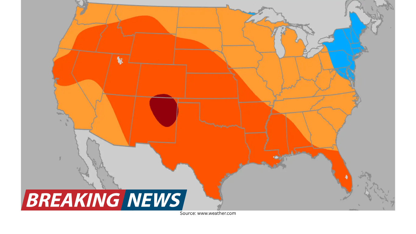
The latest April monthly outlook points to a warmer-than-previously-expected pattern for much of the United States, based on an updated assessment from The Weather Company and Atmospheric G2. The revision does not mean every region is expected to run warm, but it does expand the footprint of above-average temperatures across a broad swath of the country compared with the earlier version of the outlook.
In the updated map, above-average temperatures are favored from the Pacific Northwest to the Southwest, extending through the Central U.S. and into the Southeast. The Northeast remains the primary area expected to see below-average temperatures again this month. Alongside the temperature picture, the precipitation outlook continues to emphasize wetter-than-average conditions across much of the Central U.S., with the wetter signal in the Central Plains slightly expanded in the newest update.
Monthly outlooks are, by design, broad-brush forecasts that focus on probabilities and regional tendencies rather than day-to-day details. Still, changes between updates can be meaningful, particularly when they reflect a shift in the projected dominant pattern. In this case, the update highlights two regions that stand out for the magnitude or importance of the change: the Southeast and the Pacific Northwest (along with the Northern Plains).
Where above-average temperatures are favored
The updated outlook favors above-average temperatures across a large portion of the country. The warm signal stretches across multiple regions, creating a contiguous area of above-average temperatures that runs from the Pacific Northwest down through the Southwest, across the Central U.S., and into the Southeast.
This does not mean that every day will be warmer than normal in every location within that zone. Monthly outlooks typically indicate how the month is expected to average out overall, which can still include cool spells and stormy periods. But the headline implication is that, over the course of April, many areas outside the Northeast are more likely to end up on the warmer side of seasonal averages.
- Above-average temperatures are expected from the Pacific Northwest to the Southwest, across the Central U.S., and into the Southeast.
- Below-average temperatures are expected primarily in the Northeast.
The Northeast remains the main cooler-than-average exception
While the warm signal dominates much of the outlook, the Northeast stands out as the lone major region expected to be below average again. The forecast discussion ties this cooler tendency to a jet stream configuration that is described as a slow track to the north of the jet stream, typical for this time of year. In that setup, storms are more likely to impact the Northeast, which can keep temperatures suppressed relative to seasonal norms.
Stormier patterns can influence monthly averages in multiple ways. Cloud cover and precipitation can reduce daytime warming, while repeated intrusions of cooler air behind storm systems can prevent sustained warmth. The outlook’s emphasis is not on any single storm, but on a larger-scale pattern that favors more frequent storm impacts, which can tilt the monthly average cooler.
Key update: the Southeast is now projected to be well above average
One of the most notable changes in the updated outlook is the Southeast. In the previous forecast, the region was mainly expected to be slightly above average or warmer. In the new update, the Southeast has been upgraded to call for well above average temperatures.
This shift matters because it suggests a stronger signal for warmth than previously indicated. In practical terms, a “well above average” monthly outcome implies that, when the month is averaged, the region is more likely to see a more pronounced departure from typical April temperatures than earlier projections suggested.
As with any monthly outlook, the upgrade does not eliminate the possibility of short-lived cool periods. However, it does indicate that the balance of the month is now more likely to lean warmer, and that the overall pattern supporting warmth in the Southeast appears stronger in the updated guidance.
Key update: Pacific Northwest and Northern Plains swing warmer
The Pacific Northwest and the Northern Plains also saw a substantial change. The earlier outlook included a more prominent below-average area across the region, represented by a darker shade of blue. In the updated version, that below-average area is no longer present, replaced by a warmer-leaning signal.
This is described as a rather drastic shift, and it is one of the clearest examples in the update of how monthly outlooks can evolve as new data and model guidance are incorporated. A change from a cooler-than-average projection to a warmer one can affect expectations for the overall feel of the month, including how quickly springlike conditions may establish themselves in those areas.
It is also notable that the broader national pattern in the update supports warmth across much of the West. The Pacific Northwest’s shift fits within that larger theme, reinforcing the idea that the West is more likely to average warmer than previously expected.
Midwest and Northeast: a smaller cool zone than before
Although the Northeast remains the primary below-average region, the updated outlook indicates a slight reduction in the extent of below-average temperatures across parts of the Midwest and the Northeast compared with the previous forecast. The bulk of the Midwest and the Northeast is still expected to remain slightly below average, but the “slightly below” region has been trimmed back.
In addition, the update notes that slightly warmer-than-average temperatures are expected farther north, suggesting a subtle northward adjustment in the temperature gradient. This kind of change can be important for areas near the boundary between above- and below-average zones, where small shifts in the dominant storm track or air-mass frequency can have an outsized effect on monthly averages.
Precipitation outlook: wetter-than-average expands in the Central Plains
On the precipitation side, the updated outlook continues to call for wetter-than-average conditions across much of the Central U.S. The newest update slightly expands the wetter-than-average forecast for the Central Plains.
The forecast discussion also points out an important relationship between precipitation and temperature in parts of the Central U.S. A small region of above-average temperatures appears within the Central U.S., and the explanation offered is that increased precipitation can keep average temperatures down a bit. In other words, where rain and clouds are more frequent, temperatures may be moderated, which can influence whether an area ends up slightly warmer than average, near average, or slightly cooler than average when the month is tallied.
- Wetter-than-average conditions are expected for much of the Central U.S.
- The wetter signal in the Central Plains has been slightly expanded in the update.
- In parts of the Central U.S., higher precipitation is noted as a factor that can keep average temperatures from rising as much.
Why the Northeast is cooler: jet stream positioning and storm frequency
The outlook discussion highlights two main factors contributing to the overall temperature map, beginning with the Northeast. The cooler projection for the Northeast is linked to a jet stream pattern described as a slow track to the north of the jet stream, which is typical of this time of year. This setup can steer more storms into the region.
When storms are more frequent, temperatures can trend lower on average. Storm systems can draw cooler air into the region, and the associated cloud cover and precipitation can limit daytime warming. The outlook frames the Northeast coolness as a pattern-driven outcome rather than a one-off event, emphasizing that the storm track and its persistence are key to how the month averages out.
The polar vortex factor: how changes can influence East vs. West temperature patterns
The second major factor discussed is the polar vortex, described as a low-pressure system spinning at the North Pole. The outlook notes that when this low is strong, cool air tends to remain locked near the poles. But when the low weakens, it can allow cooler temperatures to plunge south along the Northeast.
This pattern is also described as helping to make it warmer in the West. The implication is that the same large-scale configuration that can open the door to cooler air intrusions into the Northeast can simultaneously support warmer conditions elsewhere, particularly across western parts of the country.
It is important to interpret this in the context of monthly tendencies: the outlook is not suggesting that the polar vortex alone dictates day-to-day weather, but that its strength and positioning can influence the broader pattern that, over time, shapes regional temperature departures from average.
ENSO transition: La Niña subsides, El Niño expected to develop
The outlook also references a transition in the broader climate background state. The La Niña that was ongoing during the winter has largely subsided, and an El Niño is described as being on the way. The forecast discussion states that this El Niño is expected to be strong and that it can contribute to temperature patterns over the coming months.
Because ENSO (the El Niño–Southern Oscillation) can influence large-scale atmospheric circulation, the emergence of El Niño is highlighted as another factor that may shape conditions beyond April as well. The outlook includes a specific caution about summer heat risk in the eastern U.S., stating that the emergence of a strong El Niño over the next few months should limit the risks for big heat across the eastern U.S., with the most anomalous heat extending from Texas northwestward to the Pacific Northwest.
That statement is framed as a forward-looking implication for the months ahead, rather than a direct April forecast detail. Still, it provides context for why the updated April outlook may be evolving the way it is, and how the broader pattern could continue to influence regional temperature distributions as the warm season approaches.
How to read this outlook in practical terms
For readers trying to translate a monthly outlook into everyday expectations, the key is to focus on the direction of the tilt—warmer, cooler, wetter—rather than expecting a uniform outcome. A region forecast to average above normal can still see late-season cold fronts. Likewise, a cooler-than-average region can still experience brief warm spells. The outlook is essentially describing which outcomes are more likely to win out when the month is averaged.
In this updated April picture, the most consistent messages are:
- A broad area of the country is favored to average warmer than normal, stretching across the West, Central U.S., and into the Southeast.
- The Northeast remains the primary region favored to be cooler than normal, supported by a storm-favoring jet stream configuration.
- The Central U.S. continues to show a wetter-than-average signal, with the Central Plains’ wet region slightly expanded.
- Compared with the prior outlook, the Southeast has been upgraded to well above average, and the Pacific Northwest/Northern Plains has shifted away from a previously cooler projection.
Bottom line: warmer coverage grows, but not uniformly
The updated April outlook increases the emphasis on warmth across much of the nation, particularly with an upgrade for the Southeast and a notable swing toward warmth in the Pacific Northwest and Northern Plains. At the same time, the Northeast remains the key exception, with below-average temperatures still favored due to a stormier pattern linked to the jet stream and supported by broader influences that can allow cooler air to dip south.
Meanwhile, the precipitation outlook continues to focus on wetter-than-average conditions across much of the Central U.S., with the wetter area in the Central Plains slightly expanded. Taken together, the update paints a picture of a spring month that leans warm for many, stays cooler in the Northeast, and remains active with precipitation in central parts of the country—an evolving forecast shaped by shifting large-scale patterns and the developing climate backdrop.