
Oahu Flooding Intensifies as Kona Low Brings Repeated Rounds of Heavy Rain
Worst flooding in decades, with rescues continuing
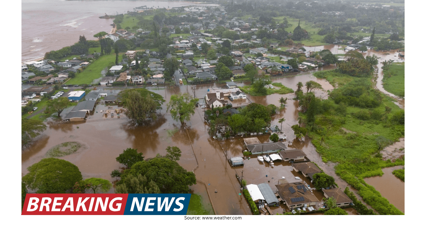
Flooding across Oahu has escalated into what officials describe as the worst the island has experienced in more than 20 years. The situation remains fluid as rainfall continues and runoff from earlier downpours keeps waterways and low-lying areas overwhelmed. Emergency crews have been conducting search-and-rescue operations as conditions allow, and more than 230 people have been rescued so far.
The impacts are widespread, stretching from neighborhoods to critical infrastructure. Officials say dozens—possibly hundreds—of homes were damaged, though a full assessment has been difficult because floodwaters have limited access to some areas. Honolulu Mayor Rick Blangiardi said officials have not yet been able to fully evaluate the destruction.
Beyond residential damage, the flooding has affected roads, schools, airports, and a hospital on Maui. Damage estimates have already reached $1 billion and are expected to climb as more information becomes available and assessments expand into harder-hit locations.
Evacuations and urgent warnings near Wahiawa dam
A major focus for emergency managers has been the Wahiawa dam, a 120-year-old structure that officials say is near critical levels and at risk of failing. Rising water levels have contributed to evacuation orders affecting thousands of residents. About 5,500 people remain under evacuation orders, in part due to concerns about the dam’s status and the possibility that it could be overtopped even if rainfall slows.
Authorities have issued stark warnings to residents in affected areas, urging immediate action. Officials told residents to leave the area right away because the dam “may collapse or breach at any time.” The warning also advised residents to carpool due to heavy traffic on the island—an indication of how quickly evacuation routes can become congested during an emergency.
These warnings reflect not only the current water level but also the cumulative effect of repeated rounds of rain. Even when rainfall rates ease, runoff can continue to feed streams and drainage systems, keeping flood danger elevated and complicating response efforts.
North Shore inundation and flash flooding
Some of the most severe conditions have been reported on Oahu’s North Shore. Emergency sirens sounded along the area as rising waters damaged homes and created dangerous conditions. Honolulu officials issued a “LEAVE NOW” evacuation order at 5:35 a.m. Friday for Waialua and Haleiwa, warning of “Extremely dangerous flooding” and noting that the Wahiawa Dam was high.
The North Shore has been under flash flood warnings since early Friday morning. Officials described the area north of Honolulu as inundated by heavy rain, with catastrophic flash flooding striking parts of Oahu. The combination of intense rainfall and saturated ground has heightened the risk that water will rise rapidly, leaving little time for residents to react.
Emergency response has included both ground and air operations. The National Guard and the Honolulu Fire Department airlifted 72 children and adults who had been attending a spring break youth camp in affected areas. The airlift underscores how quickly conditions can deteriorate and how floodwaters can isolate groups even when they are not far from populated areas.
Health impacts and the toll of prolonged exposure
Flooding emergencies are not only about water damage and rescues; they also carry serious health risks. At least 10 people have been hospitalized for hypothermia, according to officials. Hypothermia can occur when people are exposed to cold, wet conditions for extended periods, and it can affect individuals who have been stranded, evacuated, or involved in rescue situations.
As flooding persists, the risk of exposure-related illness can remain a concern, particularly for those who have been displaced or who have had to move through waterlogged areas. The ongoing nature of the event—multiple rounds of rain rather than a single storm—can also increase the likelihood that residents and responders face repeated exposure to hazardous conditions.
What’s driving the rain: a Kona low and repeated moisture surges
This round of flooding rain has been linked to a Kona low located north of Hawaii. Kona lows are low-pressure systems known for reversing winds across the Hawaiian Islands. That shift can bring heavy rainfall and gusty winds to communities that do not typically experience such severe weather.
In this case, the flood threat has been amplified by the cumulative effect of multiple rain events. Officials and meteorologists note that repeated rounds of rain and the resulting runoff since last week’s heavy rain have continued to escalate concerns. Even as rain slows at times, the runoff can keep floodwaters high and maintain pressure on drainage systems and waterways.
Adding to the challenge is the broader pattern of low-pressure systems that has continued to draw tropical Pacific moisture and push it over the islands. With very heavy rainfall from the first Kona low last weekend, followed by additional systems, the rainfall totals have mounted quickly. Without an extended break, officials warn that flooding could continue for some time.
Rain totals so far, with more expected
Parts of Oahu have recorded 8 to 12 inches of rain, and several more inches are expected through the weekend. These totals help explain why flooding has been so persistent: when heavy rainfall falls on already saturated ground, more water runs off into streams, gulches, and low-lying areas rather than soaking into the soil.
The expectation of additional rainfall is also why officials remain focused on the Wahiawa dam and why evacuation orders have remained in place for thousands of people. Even modest additional rainfall can have outsized effects when water levels are already high and infrastructure is under stress.
State response: National Guard activated, flood watch remains
The Hawaii National Guard has been activated in response to the flooding, reflecting both the scale of the emergency and the need for additional resources. Gov. Josh Green described the storm as “very severe right now,” particularly on the northern part of Oahu. He also said it would be “a very touch-and-go-day,” highlighting the uncertainty that comes with ongoing rainfall and rapidly changing conditions.
Most of the state remains under a flood watch, indicating that the threat is not confined to one neighborhood or one stretch of coastline. Flood watches are issued when conditions are favorable for flooding, and in prolonged events like this, they can remain in place as waves of moisture continue to move through the region.
How meteorologists are interpreting the larger pattern
Meteorologists have also pointed to the broader atmospheric setup that can influence where storms and heavy rainfall persist. Senior digital meteorologist Jonathan Belles said the flooding is, in some ways, connected to a heat dome entrenched over the Lower 48 states. He noted that when one area experiences heat, another often sees cooler, wetter weather.
According to Belles, the pattern has included heat in the West and slightly stormier weather in the East, and that pattern extends farther west as well. In his view, cooler, wetter weather has persisted over Hawaii and into Alaska. He added that until a major storm system shifts the pattern or it slowly breaks down, both flooding and heat could persist in their respective regions.
For Hawaii, that means the risk is not just tied to one isolated storm but to a sequence of systems and a moisture-rich environment that can repeatedly reload rainfall over the same areas.
Damage assessment underway, with costs already high
While rescues and evacuations have been the immediate priority, officials are also beginning the long process of documenting damage. The current estimate—$1 billion and climbing—reflects impacts across a wide range of facilities and services. Homes have been damaged, and key transportation and public-service infrastructure has been affected, including roads, schools, and airports.
Officials have cautioned that the true extent of the damage may not be clear for some time, especially in areas that remain difficult to access. Floodwaters can conceal structural damage, undermine roads, and leave behind debris that slows inspection and cleanup. As water recedes in some locations, additional damage may become visible.
Key facts at a glance
- Flooding on Oahu is described as the worst in more than 20 years.
- More than 230 people have been rescued as emergency operations continue.
- About 5,500 people remain under evacuation orders tied in part to concerns about the Wahiawa dam.
- Parts of Oahu have seen 8–12 inches of rain, with several more inches expected through the weekend.
- At least 10 people have been hospitalized for hypothermia.
- Damage estimates have reached $1 billion and are expected to rise.
- The Hawaii National Guard has been activated, and most of the state remains under a flood watch.
What happens next
With additional rainfall expected, officials have emphasized that the situation remains dangerous and could change quickly. Monitoring continues at the Wahiawa dam as water levels remain high, and evacuation orders are still in effect for thousands of residents. Emergency crews are continuing search-and-rescue operations, and air and ground resources remain in use as conditions require.
In the days ahead, the pace of recovery and assessment will depend heavily on rainfall trends and whether the islands receive a meaningful break between systems. For now, the combination of saturated ground, ongoing runoff, and repeated moisture surges means flood concerns are likely to remain elevated across Oahu and beyond.